Navegação por Autores IPEN "LANDULFO, E."
- Página inicial
- →
- Navegação por Autores IPEN
- Sobre
- Perfil Técnico
- Política de funcionamento
- Ajuda
- Apresentação
Navegação por Autores IPEN "LANDULFO, E."
Itens para a visualização no momento 1-20 de 49
-
GORDILLO, M.; MONICK, G.; ROMAN, R.; LYAMANI, H.; TITOS, G.; GUERRERO-RASCADO, J.L.; BASTIDAS, A.E.; HOELZEMANN, J.J.; LANDULFO, E.
 ; BARBOSA, H.M.J.; MONTILLA-ROSERO, E.
; NISPERUZA, D.. Absorbing aerosols monitoring over remote regions.
In: WORKSHOP ON LIDAR MEASUREMENTS IN LATIN AMERICA, 9th,
July 17-22, 2016,
Santos, SP.
Abstract...
2016.
Abstract:
Although the Earth’s atmosphere consists primarily of gases, aerosols and clouds play important roles in the Earth’s energy balance and climate. Aerosols alter the Earth’s energy budget directly by scattering and absorbing radiation and indirectly by modifying cloud microphysical and radiative properties. Evaluation of aerosol effects on climate must take into account high spatial and temporal variation of aerosol amounts and properties as well as the aerosol interactions with clouds and precipitation. Combustion of carbonaceous fuels for the production of energy inevitably results in the emission of gas and particulate air pollutants. A large fraction of the emitted particles are light absorbing carbonaceous aerosols that exhibit very large optical absorption across the spectrum. The most measured light absorbing carbonaceous aerosol is black carbon (BC), a unique primary tracer for combustion emissions as it is not emitted by any other sources. In the project “Absorbing aerosols monitoring over remote regions”, we have used a lightweight aircraft to obtain information on the BC and other light absorbing carbonaceous aerosols concentrations. Thus, we have determined the regional heterogeneity and vertical distribution in the atmosphere of carbonaceous aerosols with a minor payload and for a fraction of the costs associated with large airborne platforms. The aircraft has been equipped with an aethalometer to measure aerosol absorption at different wavelengths. The wavelength dependence of absorption will enable us to apportion BC concentrations to two major sources: biomass and fossil fuel combustion. Measurements have been performed throughout the flight including regions where no or very little measurements have been performed in the past, such as the Arctic, Africa, South America and over the Atlantic Ocean. Along the flight special spiral flights over lidar stations operated in the frame of the global network GALION were carried out and were analyzed in this work. Plumes of pollution and mineral dust were detected and by the use of back trajectories the possible source regions were identified.
. Absorbing aerosols monitoring over remote regions. In: WORKSHOP ON LIDAR MEASUREMENTS IN LATIN AMERICA, 9th, July 17-22, 2016, Santos, SP. Abstract... 2016. Disponível em: http://repositorio.ipen.br/handle/123456789/27995. Acesso em: $DATA.Como referenciar este item
; BARBOSA, H.M.J.; MONTILLA-ROSERO, E.
; NISPERUZA, D.. Absorbing aerosols monitoring over remote regions.
In: WORKSHOP ON LIDAR MEASUREMENTS IN LATIN AMERICA, 9th,
July 17-22, 2016,
Santos, SP.
Abstract...
2016.
Abstract:
Although the Earth’s atmosphere consists primarily of gases, aerosols and clouds play important roles in the Earth’s energy balance and climate. Aerosols alter the Earth’s energy budget directly by scattering and absorbing radiation and indirectly by modifying cloud microphysical and radiative properties. Evaluation of aerosol effects on climate must take into account high spatial and temporal variation of aerosol amounts and properties as well as the aerosol interactions with clouds and precipitation. Combustion of carbonaceous fuels for the production of energy inevitably results in the emission of gas and particulate air pollutants. A large fraction of the emitted particles are light absorbing carbonaceous aerosols that exhibit very large optical absorption across the spectrum. The most measured light absorbing carbonaceous aerosol is black carbon (BC), a unique primary tracer for combustion emissions as it is not emitted by any other sources. In the project “Absorbing aerosols monitoring over remote regions”, we have used a lightweight aircraft to obtain information on the BC and other light absorbing carbonaceous aerosols concentrations. Thus, we have determined the regional heterogeneity and vertical distribution in the atmosphere of carbonaceous aerosols with a minor payload and for a fraction of the costs associated with large airborne platforms. The aircraft has been equipped with an aethalometer to measure aerosol absorption at different wavelengths. The wavelength dependence of absorption will enable us to apportion BC concentrations to two major sources: biomass and fossil fuel combustion. Measurements have been performed throughout the flight including regions where no or very little measurements have been performed in the past, such as the Arctic, Africa, South America and over the Atlantic Ocean. Along the flight special spiral flights over lidar stations operated in the frame of the global network GALION were carried out and were analyzed in this work. Plumes of pollution and mineral dust were detected and by the use of back trajectories the possible source regions were identified.
. Absorbing aerosols monitoring over remote regions. In: WORKSHOP ON LIDAR MEASUREMENTS IN LATIN AMERICA, 9th, July 17-22, 2016, Santos, SP. Abstract... 2016. Disponível em: http://repositorio.ipen.br/handle/123456789/27995. Acesso em: $DATA.Como referenciar este itemEsta referência é gerada automaticamente de acordo com as normas do estilo IPEN/SP (ABNT NBR 6023) e recomenda-se uma verificação final e ajustes caso necessário.

-
YOSHIDA, A.C.
; LOPES, F.J.S.
; CACHEFFO, A.
; MOREIRA, G.A.
; SILVA, J.J. da
; LANDULFO, E.
. AEOLUS calibration and validation activities at SPU Lidar Station - Brazil.
In: EUROPEAN LIDAR CONFERENCE,
November 18-20, 2020,
Granada, Spain.
Resumo expandido...
2020.
p. 1-2.
. AEOLUS calibration and validation activities at SPU Lidar Station - Brazil. In: EUROPEAN LIDAR CONFERENCE, November 18-20, 2020, Granada, Spain. Resumo expandido... 2020. p. 1-2. Disponível em: http://repositorio.ipen.br/handle/123456789/32325. Acesso em: $DATA.Como referenciar este item
Esta referência é gerada automaticamente de acordo com as normas do estilo IPEN/SP (ABNT NBR 6023) e recomenda-se uma verificação final e ajustes caso necessário.
-
SAWAMURA, P.; LANDULFO, E.
. AERONET sunphotometer products and backscatter lidar data: Systematic intercomparison over the city of Sao Paulo, Brazil.
Optica Pura y Aplicada,
v. 41,
n. 2,
p. 201-205,
2008.
Palavras-Chave: optical radar; aerosols; sun; photometers; atmospheric chemistry
. AERONET sunphotometer products and backscatter lidar data: Systematic intercomparison over the city of Sao Paulo, Brazil. Optica Pura y Aplicada, v. 41, n. 2, p. 201-205, 2008. Disponível em: http://repositorio.ipen.br/handle/123456789/4953. Acesso em: $DATA.Como referenciar este itemEsta referência é gerada automaticamente de acordo com as normas do estilo IPEN/SP (ABNT NBR 6023) e recomenda-se uma verificação final e ajustes caso necessário.
-
OLIVEIRA, D.C.; HOELZEMANN, J.J.; LANDULFO, E.
; ARBOLEDAS, L.A.. Aerosol optical properties in the atmosphere of Natal/Brazil measured a sun photometer of the AERONET.
In: SP SCHOOL OF ADVANCED SCIENCE ON ATMOSPHERIC AEROSOLS,
July 22 - August 2, 2019,
São Paulo, SP.
Abstract...
São Paulo, SP: Instituto de Física - USP,
2019.
p. 95-95.
Abstract:
The study of atmospheric aerosols contributes to the understanding of radiative forcing and global
warming. In addition, aerosols may influence visibility, acid rain, human health and precipitation.
Since 2016, Natal, capital of Rio Grande do Norte, Brazil, has a solar photometer (CIMEL) of
the RIMA-AERONET network that can identify the presence of biomass burning aerosols and
desert dust from Africa. For this identification, it is aimed to characterize the optical properties
of these aerosols present in the atmosphere of Natal (RN). The data available by AERONET, at
level 1.5, Version 3, provide information on some microphysical characteristics such as Optical
Aerosol Depth (AOD), Ångström coefficient ( ), Single Scattering Albedo (SSA), Asymmetry
Factor (g), Complex Refractive Index (N), Volume Size Distribution (VSD) and Precipitable
Water. The data collection period was from August 2017 to August 2018. Aerosols were classified
based on global climatologies and their optical properties were described. Observations were
compared with daily measurements from satellites and the local LIDAR over the course of a day
for a case study. In addition, backward trajectories were modeled with the HYSPLIT model to
verify the predominant origin of the air masses. Aerosols present in the atmospheric column of
Natal showed monthly means of AOD in the range of 0.10 to 0.15 with peak of 40%, monthly
means of between 0.6 and 0.8 with peak above 30%, bimodal DTV with dominant coarse mode,
SSA about 0.8, real part around 1.5, imaginary part raging from 0.0125 to 0.0437 and g above
0.74. The Precipitable Water accompanied the increase of the precipitation for the months of
December, January, February and March. The classification identified mixed aerosols (60.40%),
marine aerosols (30.69%) and mineral dust (8.91%). The backward trajectories showed that in
51% of the cases the continental aerosols origined from the Africa.
. Aerosol optical properties in the atmosphere of Natal/Brazil measured a sun photometer of the AERONET. In: SP SCHOOL OF ADVANCED SCIENCE ON ATMOSPHERIC AEROSOLS, July 22 - August 2, 2019, São Paulo, SP. Abstract... São Paulo, SP: Instituto de Física - USP, 2019. p. 95-95. Disponível em: http://repositorio.ipen.br/handle/123456789/32218. Acesso em: $DATA.Como referenciar este item
Esta referência é gerada automaticamente de acordo com as normas do estilo IPEN/SP (ABNT NBR 6023) e recomenda-se uma verificação final e ajustes caso necessário.
-
LANDULFO, E.
; PAPAYANNIS, A.; FREITAS, A.Z.
; JORGE, M.P.P.M.; VIEIRA JUNIOR, N.D.
. Aerosols observations by an elastic LIDAR system over the city of Sao Paulo, Brazil.
In: EUROPEAN AEROSOL CONFERENCE,
Sept. 3-7, 2001,
Leipzig, Germany.
Abstracts...
2001.
p. S407-S408.
Palavras-Chave: remote sensing; neodymium lasers; aerosols; troposphere; air pollution; air pollution monitoring; brazil
. Aerosols observations by an elastic LIDAR system over the city of Sao Paulo, Brazil. In: EUROPEAN AEROSOL CONFERENCE, Sept. 3-7, 2001, Leipzig, Germany. Abstracts... 2001. p. S407-S408. Disponível em: http://repositorio.ipen.br/handle/123456789/21797. Acesso em: $DATA.Como referenciar este itemEsta referência é gerada automaticamente de acordo com as normas do estilo IPEN/SP (ABNT NBR 6023) e recomenda-se uma verificação final e ajustes caso necessário.
-
LANDULFO, E.
; PAPAYANNIS, A.; FREITAS, A.Z. de
; JORGE, M.P.P.M.; VIEIRA JUNIOR, N.D.
. Aerosols observations by elastic lidar system over the city of Sao Paulo, Brazil.
Journal of Aerosol Science,
v. 32,
n. Suppl. 1,
p. S407-S408,
2001.
DOI:
10.1016/s0021-8502(21)00186-5
Palavras-Chave: optical radar; atmospheres; brazil; aerosols; air pollution
. Aerosols observations by elastic lidar system over the city of Sao Paulo, Brazil. Journal of Aerosol Science, v. 32, n. Suppl. 1, p. S407-S408, 2001. DOI: 10.1016/s0021-8502(21)00186-5. Disponível em: http://repositorio.ipen.br/handle/123456789/8116. Acesso em: $DATA.Como referenciar este itemEsta referência é gerada automaticamente de acordo com as normas do estilo IPEN/SP (ABNT NBR 6023) e recomenda-se uma verificação final e ajustes caso necessário.
-
LANDULFO, E.
; MATOS, C.A.; TORRES, A.S.; SAWAMURA, P.; UEHARA, S.T.. Air quality assessment using a multi-instrument approach and air quality indexing in an urban area.
Atmospheric Research,
v. 85,
p. 98-111,
2007.
Palavras-Chave: backscattering; air quality; monitoring; planetary atmospheres; boundary layers; aerosols
. Air quality assessment using a multi-instrument approach and air quality indexing in an urban area. Atmospheric Research, v. 85, p. 98-111, 2007. Disponível em: http://repositorio.ipen.br/handle/123456789/5219. Acesso em: $DATA.Como referenciar este itemEsta referência é gerada automaticamente de acordo com as normas do estilo IPEN/SP (ABNT NBR 6023) e recomenda-se uma verificação final e ajustes caso necessário.
-
ANDRADE, I. da S.
; LANDULFO, E.
; ARAUJO, E.C.
; MENDONCA, F. de M.
; SALANI, M.H.G. de A.
; CORREA, T.
; MARQUES, M.T.
; COSTA, R.F. da; GUARDANI, R.. Analysis of the dispersion of aerosol in Cubatão-SP using remote sensing techniques.
In: SP SCHOOL OF ADVANCED SCIENCE ON ATMOSPHERIC AEROSOLS,
July 22 - August 2, 2019,
São Paulo, SP.
Abstract...
São Paulo, SP: Instituto de Física - USP,
2019.
p. 78-78.
Abstract:
Aerosls are emitted by a several sources, these can be antropogenic – emitted by human activities
- or natural.Their sudies are an important, because its impacts on the dynamics of the Earth’s
atmosphere are huge. The study area have one of the most important industrial complex in the
state of Sao Paulo. In the past the city of Cubatão was known as “death valey”, due to the
environmental problems caused by the high levels of pollutants that was emitted by the industries.
Following this event, regulatory laws on atmospheric emissions were developed, both at the state
and federal levels. Today, although Cubatão has lower levels of pollution and controlled industrial
emissions, but it is possible to observe overcoming air quality standards. Based on the presented
context, the present work aims to conduct a study of the dispersion of aerosols in the region
of Cubatão-SP using several techniques, such as: remote sensing (elastic lidar and wind lidar),
satellite data, air quality information and also simulations of air masses using a model.
. Analysis of the dispersion of aerosol in Cubatão-SP using remote sensing techniques. In: SP SCHOOL OF ADVANCED SCIENCE ON ATMOSPHERIC AEROSOLS, July 22 - August 2, 2019, São Paulo, SP. Abstract... São Paulo, SP: Instituto de Física - USP, 2019. p. 78-78. Disponível em: http://repositorio.ipen.br/handle/123456789/32216. Acesso em: $DATA.Como referenciar este item
Esta referência é gerada automaticamente de acordo com as normas do estilo IPEN/SP (ABNT NBR 6023) e recomenda-se uma verificação final e ajustes caso necessário.
-
MOREIRA, G.A.
; LOPES, F.J.S.
; CODATO, G.; SANCHEZ, M.P.; SILVA, J.J. da
; GOMES, A.A.
; TITO, J.V.; SILVA, L.A.H.; SILVEIRA, L.C.; LANDULFO, E.
; OLIVEIRA, A.P.. Analyzing the effects of biomass in the Amazon region on the São Paulo urban boundary layer.
In: EUROPEAN LIDAR CONFERENCE,
November 18-20, 2020,
Granada, Spain.
Resumo expandido...
2020.
p. 1-2.
. Analyzing the effects of biomass in the Amazon region on the São Paulo urban boundary layer. In: EUROPEAN LIDAR CONFERENCE, November 18-20, 2020, Granada, Spain. Resumo expandido... 2020. p. 1-2. Disponível em: http://repositorio.ipen.br/handle/123456789/32326. Acesso em: $DATA.Como referenciar este item
Esta referência é gerada automaticamente de acordo com as normas do estilo IPEN/SP (ABNT NBR 6023) e recomenda-se uma verificação final e ajustes caso necessário.
-
MOREIRA, G. de A.
; GUERRERO-RASCADO, J.L.; BENAVENT-OLTRA, J.A.; ORTIZ-AMEZCUA, P.; LANDULFO, E.
; ALADOS-ARBOLEDAS, L.. Analyzing the turbulent structure of the Planetary Boundary Layer by Elastic lidar.
In: WORKSHOP ON LIDAR MEASUREMENTS IN LATIN AMERICA, 9th,
July 17-22, 2016,
Santos, SP.
Abstract...
2016.
Abstract:
The part of troposphere in direct contact with Earth’s surface is known as planetary boundary layer (PBL). This region, endowed with turbulent behavior, is the main responsible for the exchange of momentum and energy between the atmosphere and surface. These characteristics make the understanding of PBL structure important for a wide set of studies, which vary from weather forecasting to pollutant dispersion. However, this layer has a great variability throughout the day, and the classical instruments used to study it has temporal limitation (radiosoundings) or spatial limitation (anemometric and eddy covariance towers). Under this scenario, lidar systems have been fairly applied in the last decade due to the absence of such kind constraints.
In this study, we used an elastic lidar to analyze the turbulent behavior of PBL and its internal processes. VELETA, a Raman lidar (Raymetrics Inc) operating at 355 and 387 nm with 1-s temporal and 7.5-m spatial resolutions, held the data acquisition. This system, located at IISTA-CEAMA (Andalusian Institute for Earth System Research) in Granada
– Spain, is part of EARLINET (European Aerosol Research Lidar Network).We obtained the value of 1-h averaged atmospheric transmittance, T(r),and from it 1-s backscatter profiles, β(r), are derived. These values of β(r) were used to estimate the high order statistics moments (variance, skewness and kurtosis) and energy spectrum.
This study enabled us to carry out a detailed description of PBL and it confirms the feasibility of elastic lidar signals
for the characterization of the PBL turbulence as evidenced by other more sophisticated techniques such as high spectral resolution lidars (McNicholas, 2014) and rotational Raman lidars (Behrendt, 2015). In the near future we will apply the same methodology to a Doppler lidar and we will also study aerosol fluxes from the synergy of Doppler and elastic lidars.
. Analyzing the turbulent structure of the Planetary Boundary Layer by Elastic lidar. In: WORKSHOP ON LIDAR MEASUREMENTS IN LATIN AMERICA, 9th, July 17-22, 2016, Santos, SP. Abstract... 2016. Disponível em: http://repositorio.ipen.br/handle/123456789/28000. Acesso em: $DATA.Como referenciar este item
Esta referência é gerada automaticamente de acordo com as normas do estilo IPEN/SP (ABNT NBR 6023) e recomenda-se uma verificação final e ajustes caso necessário.
-
MARIANO, G.L.; LOPES, F.J.S.; JORGE, M.P.P.M.; LANDULFO, E.
. Assessment of biomass burnings activity with the synergy of sunphotometric and LIDAR measurements in Sao Paulo, Brazil.
Atmospheric Research,
v. 98,
p. 486-499,
2010.
Palavras-Chave: brazil; biomass; burnup; aerosols; air pollution monitoring; photometers
. Assessment of biomass burnings activity with the synergy of sunphotometric and LIDAR measurements in Sao Paulo, Brazil. Atmospheric Research, v. 98, p. 486-499, 2010. Disponível em: http://repositorio.ipen.br/handle/123456789/4649. Acesso em: $DATA.Como referenciar este itemEsta referência é gerada automaticamente de acordo com as normas do estilo IPEN/SP (ABNT NBR 6023) e recomenda-se uma verificação final e ajustes caso necessário.
-
LOPES, F.J.S.; LANDULFO, E.
; VAUGHAN, M.A.. Assessment of the CALIPSO lidar 532 nm version 3 lidas ratio models using a ground-based lidar and AERONET sun photometers in Brazil.
Atmospheric Measurement Techniques Discussions,
v. 6,
p. 1143-1199,
2013.
Palavras-Chave: brazil; optical radar; satellites; remote sensing; sun; photometers; aerosol monitoring; climates
. Assessment of the CALIPSO lidar 532 nm version 3 lidas ratio models using a ground-based lidar and AERONET sun photometers in Brazil. Atmospheric Measurement Techniques Discussions, v. 6, p. 1143-1199, 2013. Disponível em: http://repositorio.ipen.br/handle/123456789/8482. Acesso em: $DATA.Como referenciar este itemEsta referência é gerada automaticamente de acordo com as normas do estilo IPEN/SP (ABNT NBR 6023) e recomenda-se uma verificação final e ajustes caso necessário.
-
SANTOS, P.A.A.; SAKAGAMI, Y.; HAAS, R.; PASSOS, J.C.; TAVES, F.F.; NASSIF, F.; MOREIRA, A.; MOREIRA, G.A.
; MARQUES, M.T.A.
; BEU, C.
; LANDULFO, E.
. Atmospheric stability using Doppler Wind Lidar profiler: a Case Study in Florianópolis Island.
In: WORKSHOP ON LIDAR MEASUREMENTS IN LATIN AMERICA, 9th,
July 17-22, 2016,
Santos, SP.
Abstract...
2016.
Abstract:
The effects of atmospheric stability can be important for many wind energy applications. This work aims to investigate the atmospheric stability using two Doppler wind lidar profilers based on a simple method that analyses how the wind shear variates with height. The experiment was carried on Florianopolis Island, located in the south coast of Brazil. The dataset covered a period from December 2014 to February 2015. The Windcube08 lidar has a range from 40m to 500m and the Windcube70 lidar was setup to range from 100m to 1000m. Both lidars recorded a 10min average wind speed with a vertical resolution of 20m. In addition, a 3D sonic anemometer measured turbulent fluxes at 20Hz. The method evaluated the variation of wind shear with height and was associated with the stability classes based on Obukhov Length. The wind speed of the two lidars was compared at 100m, 200m, 300m, 400m and 500m. This comparison showed an excellent agreement, with values better than R2=0.996 and RMSE=0.15 m/s. The results of wind profile indicated an unique condition at night, where were consistently observed convective wind profiles from 40m to 120m and stratified flow above 120m. Then, the presented method was adjusted to consider wind profile heights from 120m to 300m. The analysis of the atmospheric stability also presented a good agreement when comparing both lidars. The Very stable, stable and near stable conditions represented 41,2% (Windcube08) and 27,6% (Windcube70). On the other hand, the unstable condition was dominated by a very unstable condition with 21% and 38,7%, respectively. The neutral condition was the most frequent with 36,8% and 32,2%, respectively. The results of atmospheric stability classes diverged between the two lidars from 5h to 10h UTC, because of differences on wind speed average of around -0.8 m/s from 100m to 200m. In conclusion, the site presented specific conditions, which showed the challenges to propose an universal method to estimate the atmospheric stability using only doppler wind lidar data. However, the method achieved good agreement when comparing the wind profile with the atmospheric stability classes.
. Atmospheric stability using Doppler Wind Lidar profiler: a Case Study in Florianópolis Island. In: WORKSHOP ON LIDAR MEASUREMENTS IN LATIN AMERICA, 9th, July 17-22, 2016, Santos, SP. Abstract... 2016. Disponível em: http://repositorio.ipen.br/handle/123456789/28004. Acesso em: $DATA.Como referenciar este item
Esta referência é gerada automaticamente de acordo com as normas do estilo IPEN/SP (ABNT NBR 6023) e recomenda-se uma verificação final e ajustes caso necessário.
-
GUERRERO-RASCADO, J.L.; LANDULFO, E.
; LOPES, F.J.S.
; BARBOSA, H.M.J.; GOUVEIA, D.A.; FORNO, R.N.; SANCHEZ, M.F.; BASTIDAS, A.E.; NISPERUZA, D.; MONTILLA-ROSERO, E.; SILVA, A.; HOELZEMANN, J.J.; RISTORI, P.; QUEL, E.J.; BARJA, B.; ANTUNA, J.A.. Checking the instrumental performance of LALINET: quality assurance during the period 2014-2015.
In: WORKSHOP ON LIDAR MEASUREMENTS IN LATIN AMERICA, 9th,
July 17-22, 2016,
Santos, SP.
Abstract...
2016.
Abstract:
The recently published study of Guerrero-Rascado et al. (2016) reporting a diagnosis on the LALINET network instrumentation initiated the analysis of the instrumental status of LALINET. The current study presents the instrumental activities performed on LALINET with the aim of improving the monitoring capabilities of this network to characterize the aerosol particle field on continental scale. To guarantee the quality and standardization of products offered by the LALINET network, a robust quality assurance program based on regular instrumental tests (inherited from EARLINET, the European Aerosol Research Lidar Network, Pappalardo et al. [2014]) has been applied. In particular, the quality assurance tests performed were: (i) quadrants telecover and in-out telecover tests to analyze lidar signals in the near range, (ii) Rayleigh fit to analyze lidar signals in the far range, (iii) dark current measurement to evaluate electronic noise and (iv) zero-bin calibration / trigger delay to evaluate time delays. These tests, mandatory for all LALINET systems, were carried out annually. This paper reveals the evolution of the instrumental quality in the network, highlighting the improvements/degradations which have been taking place under the period of analysis 2014-2015.
. Checking the instrumental performance of LALINET: quality assurance during the period 2014-2015. In: WORKSHOP ON LIDAR MEASUREMENTS IN LATIN AMERICA, 9th, July 17-22, 2016, Santos, SP. Abstract... 2016. Disponível em: http://repositorio.ipen.br/handle/123456789/27996. Acesso em: $DATA.Como referenciar este item
Esta referência é gerada automaticamente de acordo com as normas do estilo IPEN/SP (ABNT NBR 6023) e recomenda-se uma verificação final e ajustes caso necessário.
-
CACHEFFO, A.; LOPES, F.J.S.
; YOSHIDA, A.C.; LANDULFO, E.
. Classifying aerosols with machine learning techniques using the AERONET and CALIPSO satellite databases.
In: SP SCHOOL OF ADVANCED SCIENCE ON ATMOSPHERIC AEROSOLS,
July 22 - August 2, 2019,
São Paulo, SP.
Abstract...
São Paulo, SP: Instituto de Física - USP,
2019.
p. 102-102.
Abstract:
In this work, our intention is to develop ways to correlate and classify several types of aerosols, by
practical and objective manners, with the aim of machine learning techniques (specially decision
trees and random forests) [1, 2]. For this purpose, we are intended to use the AERONET
(Aerosol Robotic Network) and CALIPSO (Cloud-Aerosol Lidar and Infrared Pathfinder Satellite
Observations) satellite databases [3]. The AERONET database, which includes measurements
made since year 2000, will provide to us a reference standard for the categorization and classification
of aerosols present in atmosphere [3]. Following this, the databases for the measurements made
by the CALIPSO satellite will be addressed, also with the objective of categorizing and classifying
aerosols. Such data mining processes will enable us to carry out statistical and climatological
analyzes of these databases, allowing a better study of the atmospheric behavior of aerosols
in the Earth’s atmosphere [4]. We believe that the development of such tools and techniques
for treatment of data provided by AERONET and CALIPSO will contribute greatly to a better
understanding of climate change processes on Earth, a subject of scientific interest, especially in
recent years.
. Classifying aerosols with machine learning techniques using the AERONET and CALIPSO satellite databases. In: SP SCHOOL OF ADVANCED SCIENCE ON ATMOSPHERIC AEROSOLS, July 22 - August 2, 2019, São Paulo, SP. Abstract... São Paulo, SP: Instituto de Física - USP, 2019. p. 102-102. Disponível em: http://repositorio.ipen.br/handle/123456789/32219. Acesso em: $DATA.Como referenciar este item
Esta referência é gerada automaticamente de acordo com as normas do estilo IPEN/SP (ABNT NBR 6023) e recomenda-se uma verificação final e ajustes caso necessário.
-
LANDULFO, E.
; FREITAS, A.Z.
; NOGUEIRA, G.E.C.
; WETTER, N.U.
; MORATO, S.P.
; ROSSI, W.
; VIEIRA JUNIOR, N.D.
. A compact elastic backscattering lidar system for aerosol monitoring over the city of Sao Paulo, Brazil.
In: INTERNATIONAL LASER RADAR CONFERENCE, 20th,
July 10-14, 2000,
Vichy, France.
Abstracts...
2000.
Palavras-Chave: air pollution monitoring; aerosols; backscattering; urban areas; pollution; brazil
. A compact elastic backscattering lidar system for aerosol monitoring over the city of Sao Paulo, Brazil. In: INTERNATIONAL LASER RADAR CONFERENCE, 20th, July 10-14, 2000, Vichy, France. Abstracts... 2000. Disponível em: http://repositorio.ipen.br/handle/123456789/20762. Acesso em: $DATA.Como referenciar este itemEsta referência é gerada automaticamente de acordo com as normas do estilo IPEN/SP (ABNT NBR 6023) e recomenda-se uma verificação final e ajustes caso necessário.
-
MOREIRA, G.A.
; GUERRERO-RASCADO, J.L.; BENAVENT-OLTRA, J.A.; ORTIZ-AMEZCUA, P.; LANDULFO, E.
; ALADOS-ARBOLEDAS, L.. A comparison among statistical and classical methods to obtain the planetary boundary layer height by lidar data.
In: WORKSHOP ON LIDAR MEASUREMENTS IN LATIN AMERICA, 9th,
July 17-22, 2016,
Santos, SP.
Abstract...
2016.
Abstract:
The planetary boundary layer (PBL) is the lowermost part of the troposphere, which is characterized by large variability in its statical stability and turbulence along the day. This varying behavior makes the PBL height determination a key for a wide set of studies, including pollutant dispersion and weather forecasting. Due to its variability throughout the day, PBL monitoring requires instrumentation with high temporal and spatial resolution. During the last two decades lidar (light detect and ranging) systems have been largely applied to this kind of study.
However, the PBLH discrimination by lidar is not straightforward, because algorithms are necessary to interpret the experimental data and remove ambiguities in layer attribution. Nevertheless, under situations of high atmospheric complexity, the algorithms might misunderstand PBLH top with other sublayers.
In this study, we will compare the classical methods (Variance, Gradient and Wavelet Covariance Transform) with a statistical method based on Kalman filter, in an attempt to evaluate the strengths and weakness of each one. The measurements were recorded in the city of Granada – Spain during 2015 with the Raman lidar VELETA (Raymetrics Inc), operating at 355 and 387 nm with 1-min and 7.5-m resolutions. All methods were validated by Bulk Richardson Number obtained from simultaneous, collocated radiosounding data.
This study will give us background for further improvements of the algorithms used in order to solve the difficulties encountered in the process of PBL height detection. In particular, the results will contribute to improve synergic methodologies combining different instruments.
. A comparison among statistical and classical methods to obtain the planetary boundary layer height by lidar data. In: WORKSHOP ON LIDAR MEASUREMENTS IN LATIN AMERICA, 9th, July 17-22, 2016, Santos, SP. Abstract... 2016. Disponível em: http://repositorio.ipen.br/handle/123456789/27999. Acesso em: $DATA.Como referenciar este item
Esta referência é gerada automaticamente de acordo com as normas do estilo IPEN/SP (ABNT NBR 6023) e recomenda-se uma verificação final e ajustes caso necessário.
-
LANDULFO, E.
; FREITAS, S.R.; LONGO, K.M.; UEHARA, S.T.; SAWAMURA, P.. A comparison study of regional atmospheric simulations with and elastic backscattering lidar and sunphotometry in an urban area.
Atmospheric Chemistry and Physics,
v. 9,
n. 18,
p. 6767-6774,
2009.
DOI:
10.5194/acpd-9-9151-2009
Palavras-Chave: urban areas; atmospheres; simulation; optical radar; backscattering; sun; photometers; air pollution; comparative evaluations
. A comparison study of regional atmospheric simulations with and elastic backscattering lidar and sunphotometry in an urban area. Atmospheric Chemistry and Physics, v. 9, n. 18, p. 6767-6774, 2009. DOI: 10.5194/acpd-9-9151-2009. Disponível em: http://repositorio.ipen.br/handle/123456789/4840. Acesso em: $DATA.Como referenciar este itemEsta referência é gerada automaticamente de acordo com as normas do estilo IPEN/SP (ABNT NBR 6023) e recomenda-se uma verificação final e ajustes caso necessário.
-
LANDULFO, E.
; ZAMBONI, C.B.
; LAPOLLI, A.L.
; SAXENA, R.N.
. Correlacao angular gama-gama para transicoes no sub(72) Ge.
In: 44a. REUNIAO ANUAL DA SBPC,
12-17 de julho, 1992,
Sao Paulo, SP.
Comunicacao...
1992.
Palavras-Chave: germanium 72; angular correlation
. Correlacao angular gama-gama para transicoes no sub(72) Ge. In: 44a. REUNIAO ANUAL DA SBPC, 12-17 de julho, 1992, Sao Paulo, SP. Comunicacao... 1992. Disponível em: http://repositorio.ipen.br/handle/123456789/21753. Acesso em: $DATA.Como referenciar este itemEsta referência é gerada automaticamente de acordo com as normas do estilo IPEN/SP (ABNT NBR 6023) e recomenda-se uma verificação final e ajustes caso necessário.
-
LANDULFO, E.
; LAPOLLI, A.L.
; ZAMBONI, C.B.
; SAXENA, R.N.
. Correlacao angular gama-gama para transicoes no sup(72)Ge.
In: 13a. REUNIAO DE TRABALHO SOBRE FISICA NUCLEAR NO BRASIL,
2-6 de setembro, 1990,
Caxambu, MG.
1990.
Palavras-Chave: germanium 72; angular correlation
. Correlacao angular gama-gama para transicoes no sup(72)Ge. In: 13a. REUNIAO DE TRABALHO SOBRE FISICA NUCLEAR NO BRASIL, 2-6 de setembro, 1990, Caxambu, MG. 1990. Disponível em: http://repositorio.ipen.br/handle/123456789/14880. Acesso em: $DATA.Como referenciar este itemEsta referência é gerada automaticamente de acordo com as normas do estilo IPEN/SP (ABNT NBR 6023) e recomenda-se uma verificação final e ajustes caso necessário.
Itens para a visualização no momento 1-20 de 49
Buscar no repositório
Navegar
Minha conta
Visualizar
A pesquisa no RD utiliza os recursos de busca da maioria das bases de dados. No entanto algumas dicas podem auxiliar para obter um resultado mais pertinente.
✔ É possível efetuar a busca de um autor ou um termo em todo o RD, por meio do Buscar no Repositório , isto é, o termo solicitado será localizado em qualquer campo do RD. No entanto esse tipo de pesquisa não é recomendada a não ser que se deseje um resultado amplo e generalizado.
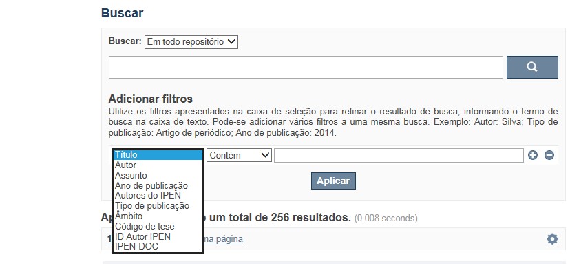
✔ A pesquisa apresentará melhor resultado selecionando um dos filtros disponíveis em Navegar
✔ Os filtros disponíveis em Navegar tais como: Coleções, Ano de publicação, Títulos, Assuntos, Autores, Revista, Tipo de publicação são autoexplicativos. O filtro, Autores IPEN apresenta uma relação com os autores vinculados ao IPEN; o ID Autor IPEN diz respeito ao número único de identificação de cada autor constante no RD e sob o qual estão agrupados todos os seus trabalhos independente das variáveis do seu nome; Tipo de acesso diz respeito à acessibilidade do documento, isto é , sujeito as leis de direitos autorais, ID RT apresenta a relação dos relatórios técnicos, restritos para consulta das comunidades indicadas.
A opção Busca avançada utiliza os conectores da lógica boleana, é o melhor recurso para combinar chaves de busca e obter documentos relevantes à sua pesquisa, utilize os filtros apresentados na caixa de seleção para refinar o resultado de busca. Pode-se adicionar vários filtros a uma mesma busca.
Exemplo:
Buscar os artigos apresentados em um evento internacional de 2015, sobre loss of coolant, do autor Maprelian.
Autor: Maprelian
Título: loss of coolant
Tipo de publicação: Texto completo de evento
Ano de publicação: 2015
✔ Para indexação dos documentos é utilizado o Thesaurus do INIS, especializado na área nuclear e utilizado em todos os países membros da International Atomic Energy Agency – IAEA , por esse motivo, utilize os termos de busca de assunto em inglês; isto não exclui a busca livre por palavras, apenas o resultado pode não ser tão relevante ou pertinente.
✔ 95% do RD apresenta o texto completo do documento com livre acesso, para aqueles que apresentam o ![]() significa que e o documento está sujeito as leis de direitos autorais, solicita-se nesses casos contatar a Biblioteca do IPEN,
bibl@ipen.br
.
significa que e o documento está sujeito as leis de direitos autorais, solicita-se nesses casos contatar a Biblioteca do IPEN,
bibl@ipen.br
.
✔ Ao efetuar a busca por um autor o RD apresentará uma relação de todos os trabalhos depositados no RD. No lado direito da tela são apresentados os coautores com o número de trabalhos produzidos em conjunto bem como os assuntos abordados e os respectivos anos de publicação agrupados.
✔ O RD disponibiliza um quadro estatístico de produtividade, onde é possível visualizar o número dos trabalhos agrupados por tipo de coleção, a medida que estão sendo depositados no RD.
✔ Na página inicial nas referências são sinalizados todos os autores IPEN, ao clicar nesse símbolo ![]() será aberta uma nova página correspondente à aquele autor – trata-se da página do pesquisador.
será aberta uma nova página correspondente à aquele autor – trata-se da página do pesquisador.
✔ Na página do pesquisador, é possível verificar, as variações do nome, a relação de todos os trabalhos com texto completo bem como um quadro resumo numérico; há links para o Currículo Lattes e o Google Acadêmico ( quando esse for informado).
ATENÇÃO!
ESTE TEXTO "AJUDA" ESTÁ SUJEITO A ATUALIZAÇÕES CONSTANTES, A MEDIDA QUE NOVAS FUNCIONALIDADES E RECURSOS DE BUSCA FOREM SENDO DESENVOLVIDOS PELAS EQUIPES DA BIBLIOTECA E DA INFORMÁTICA.
O gerenciamento do Repositório está a cargo da Biblioteca do IPEN. Constam neste RI, até o presente momento 20.950 itens que tanto podem ser artigos de periódicos ou de eventos nacionais e internacionais, dissertações e teses, livros, capítulo de livros e relatórios técnicos. Para participar do RI-IPEN é necessário que pelo menos um dos autores tenha vínculo acadêmico ou funcional com o Instituto. Nesta primeira etapa de funcionamento do RI, a coleta das publicações é realizada periodicamente pela equipe da Biblioteca do IPEN, extraindo os dados das bases internacionais tais como a Web of Science, Scopus, INIS, SciElo além de verificar o Currículo Lattes. O RI-IPEN apresenta também um aspecto inovador no seu funcionamento. Por meio de metadados específicos ele está vinculado ao sistema de gerenciamento das atividades do Plano Diretor anual do IPEN (SIGEPI). Com o objetivo de fornecer dados numéricos para a elaboração dos indicadores da Produção Cientifica Institucional, disponibiliza uma tabela estatística registrando em tempo real a inserção de novos itens. Foi criado um metadado que contém um número único para cada integrante da comunidade científica do IPEN. Esse metadado se transformou em um filtro que ao ser acionado apresenta todos os trabalhos de um determinado autor independente das variáveis na forma de citação do seu nome.
A elaboração do projeto do RI do IPEN foi iniciado em novembro de 2013, colocado em operação interna em julho de 2014 e disponibilizado na Internet em junho de 2015. Utiliza o software livre Dspace, desenvolvido pelo Massachusetts Institute of Technology (MIT). Para descrição dos metadados adota o padrão Dublin Core. É compatível com o Protocolo de Arquivos Abertos (OAI) permitindo interoperabilidade com repositórios de âmbito nacional e internacional.
1. Portaria IPEN-CNEN/SP nº 387, que estabeleceu os princípios que nortearam a criação do RDI, clique aqui.
2. A experiência do Instituto de Pesquisas Energéticas e Nucleares (IPEN-CNEN/SP) na criação de um Repositório Digital Institucional – RDI, clique aqui.
O Repositório Digital do IPEN é um equipamento institucional de acesso aberto, criado com o objetivo de reunir, preservar, disponibilizar e conferir maior visibilidade à Produção Científica publicada pelo Instituto, desde sua criação em 1956.
Operando, inicialmente como uma base de dados referencial o Repositório foi disponibilizado na atual plataforma, em junho de 2015. No Repositório está disponível o acesso ao conteúdo digital de artigos de periódicos, eventos, nacionais e internacionais, livros, capítulos, dissertações, teses e relatórios técnicos.
A elaboração do projeto do RI do IPEN foi iniciado em novembro de 2013, colocado em operação interna em julho de 2014 e disponibilizado na Internet em junho de 2015. Utiliza o software livre Dspace, desenvolvido pelo Massachusetts Institute of Technology (MIT). Para descrição dos metadados adota o padrão Dublin Core. É compatível com o Protocolo de Arquivos Abertos (OAI) permitindo interoperabilidade com repositórios de âmbito nacional e internacional.
O gerenciamento do Repositório está a cargo da Biblioteca do IPEN. Constam neste RI, até o presente momento 20.950 itens que tanto podem ser artigos de periódicos ou de eventos nacionais e internacionais, dissertações e teses, livros, capítulo de livros e relatórios técnicos. Para participar do RI-IPEN é necessário que pelo menos um dos autores tenha vínculo acadêmico ou funcional com o Instituto. Nesta primeira etapa de funcionamento do RI, a coleta das publicações é realizada periodicamente pela equipe da Biblioteca do IPEN, extraindo os dados das bases internacionais tais como a Web of Science, Scopus, INIS, SciElo além de verificar o Currículo Lattes. O RI-IPEN apresenta também um aspecto inovador no seu funcionamento. Por meio de metadados específicos ele está vinculado ao sistema de gerenciamento das atividades do Plano Diretor anual do IPEN (SIGEPI). Com o objetivo de fornecer dados numéricos para a elaboração dos indicadores da Produção Cientifica Institucional, disponibiliza uma tabela estatística registrando em tempo real a inserção de novos itens. Foi criado um metadado que contém um número único para cada integrante da comunidade científica do IPEN. Esse metadado se transformou em um filtro que ao ser acionado apresenta todos os trabalhos de um determinado autor independente das variáveis na forma de citação do seu nome.