Navegação por Autores IPEN "YOSHIDA, ALEXANDRE C."
- Página inicial
- →
- Navegação por Autores IPEN
- Sobre
- Perfil Técnico
- Política de funcionamento
- Ajuda
- Apresentação
Navegação por Autores IPEN "YOSHIDA, ALEXANDRE C."
Itens para a visualização no momento 1-8 de 8
-
MOREIRA, GREGORI de A.
 ; ANDRADE, IZABEL da S.
; CACHEFFO, ALEXANDRE
; YOSHIDA, ALEXANDRE C.
; GOMES, ANTONIO A.
; SILVA, JONATAN J. da
; LOPES, FABIO J. da S.
; LANDULFO, EDUARDO
. COVID-19 outbreak and air quality: analyzing the influence of physical distancing and the resumption of activities in São Paulo municipality.
Urban Climate,
v. 37,
p. 1-15,
2021.
DOI:
10.1016/j.uclim.2021.100813
Abstract:
This work compares variations in the concentrations and air quality indexes of the pollutants PM10, PM2.5, CO, and NO2, during the
COVID-19 outbreak in São Paulo Municipality. Such comparisons considered the period of physical distancing (autumn) and the three
first months of economic activities’ resumption (winter). The concentrations and indexes observed in 2020 were compared with their
correspondent values measured in the three preceding years. Also, from a supervised machine learning algorithm, the correspondent
2020 expected values were predicted and used in these comparisons. In order to analyze the influence of meteorological conditions, the
seasons studied were characterized using remote sensing and surface data. The pollutants predominantly emitted by the vehicle fleet
(CO and NO2) had reductions in their concentrations, with values always below the predictions and good air quality indexes. However,
the pollutants whose concentration is less dependent on automotive emissions (PM10 and PM2.5) had high proximity to the predictions
during the autumn and lower values during some periods in winter. This reduction was not enough to avoid days with a moderate air
quality index. The approximation of the average concentrations of PM10, PM2.5, and CO to the prediction, from the second-half August 2020, indicates the influence of activities’ resumption in air quality.
; ANDRADE, IZABEL da S.
; CACHEFFO, ALEXANDRE
; YOSHIDA, ALEXANDRE C.
; GOMES, ANTONIO A.
; SILVA, JONATAN J. da
; LOPES, FABIO J. da S.
; LANDULFO, EDUARDO
. COVID-19 outbreak and air quality: analyzing the influence of physical distancing and the resumption of activities in São Paulo municipality.
Urban Climate,
v. 37,
p. 1-15,
2021.
DOI:
10.1016/j.uclim.2021.100813
Abstract:
This work compares variations in the concentrations and air quality indexes of the pollutants PM10, PM2.5, CO, and NO2, during the
COVID-19 outbreak in São Paulo Municipality. Such comparisons considered the period of physical distancing (autumn) and the three
first months of economic activities’ resumption (winter). The concentrations and indexes observed in 2020 were compared with their
correspondent values measured in the three preceding years. Also, from a supervised machine learning algorithm, the correspondent
2020 expected values were predicted and used in these comparisons. In order to analyze the influence of meteorological conditions, the
seasons studied were characterized using remote sensing and surface data. The pollutants predominantly emitted by the vehicle fleet
(CO and NO2) had reductions in their concentrations, with values always below the predictions and good air quality indexes. However,
the pollutants whose concentration is less dependent on automotive emissions (PM10 and PM2.5) had high proximity to the predictions
during the autumn and lower values during some periods in winter. This reduction was not enough to avoid days with a moderate air
quality index. The approximation of the average concentrations of PM10, PM2.5, and CO to the prediction, from the second-half August 2020, indicates the influence of activities’ resumption in air quality.
Palavras-Chave: coronaviruses; urban areas; urban populations; emergency plans; air quality; air pollution monitors; pollution sources; optical radar
. COVID-19 outbreak and air quality: analyzing the influence of physical distancing and the resumption of activities in São Paulo municipality. Urban Climate, v. 37, p. 1-15, 2021. DOI: 10.1016/j.uclim.2021.100813. Disponível em: http://repositorio.ipen.br/handle/123456789/32059. Acesso em: $DATA.Como referenciar este itemEsta referência é gerada automaticamente de acordo com as normas do estilo IPEN/SP (ABNT NBR 6023) e recomenda-se uma verificação final e ajustes caso necessário.

-
SILVA, JONATAN da
; MORAIS, FERNANDO G.
; FRANCO, MARCO A.; LOPES, FABIO J.S.
; ARRUDA, GREGORI de A.
; YOSHIDA, ALEXANDRE C.
; CORREIA, ALEXANDRE; LANDULFO, EDUARDO
. Exploring the twilight zone: a multi-sensor approach.
EPJ Web of Conferences,
v. 237,
p. 1-4,
2020.
DOI:
10.1051/epjconf/202023707015
Abstract:
This study shows a set of analysis of
measurements from ground-based and satellite
instruments to characterize the twilight zone (TLZ)
between clouds and aerosols in São Paulo, Brazil.
In the vicinity of clouds turbulence measurements
showed an intense upward movement of aerosol
layers, while sunphotometer results showed an
increase in aerosol optical depth, and lidar
measurements showed an increase in the
backscatter vertical profile signal.
Palavras-Chave: atmospheres; clouds; earth atmosphere; aerosols; optical radar; satellites; urban areas; radiations; meteorology
. Exploring the twilight zone: a multi-sensor approach. EPJ Web of Conferences, v. 237, p. 1-4, 2020. DOI: 10.1051/epjconf/202023707015. Disponível em: http://repositorio.ipen.br/handle/123456789/31477. Acesso em: $DATA.Como referenciar este itemEsta referência é gerada automaticamente de acordo com as normas do estilo IPEN/SP (ABNT NBR 6023) e recomenda-se uma verificação final e ajustes caso necessário.
-
MOREIRA, GREGORI de A.
; ANDRADE, IZABEL da S.
; CACHEFFO, ALEXANDRE
; LOPES, FABIO J. da S.
; YOSHIDA, ALEXANDRE C.
; GOMES, ANTONIO A.
; SILVA, JONATAN J. da
; LANDULFO, EDUARDO
. Influence of a biomass-burning event in PM2.5 concentration and air quality: a case study in the Metropolitan Area of São Paulo.
Sensors,
v. 21,
n. 2,
p. 1-19,
2021.
DOI:
10.3390/s21020425
Abstract:
Severe biomass burning (BB) events have become increasingly common in South America in the last few years, mainly due to the high number of wildfires observed recently. Such incidents can negatively influence the air quality index associated with PM2.5 (particulate matter, which is harmful to human health). A study performed in the Metropolitan Area of São Paulo (MASP) took place on selected days of July 2019, evaluated the influence of a BB event on air quality. Use of combined remote sensing, a surface monitoring system and data modeling and enabled detection of the BB plume arrival (light detection and ranging (lidar) ratio of (50 ± 34) sr at 532 nm, and (72 ± 45) sr at 355 nm) and how it affected the Ångström exponent (>1.3), atmospheric optical depth (>0.7), PM2.5 concentrations (>25 µg.m−3), and air quality classification. The utilization of high-order statistical moments, obtained from elastic lidar, provided a new way to observe the entrainment process, allowing understanding of how a decoupled aerosol layer influences the local urban area. This new novel approach enables a lidar system to obtain the same results as a more complex set of instruments and verify how BB events contribute from air masses aloft towards near ground ones.
Palavras-Chave: air quality; biomass; burns; particulates; remote sensing; moments method; statistics; nature reserves; optical radar
. Influence of a biomass-burning event in PM2.5 concentration and air quality: a case study in the Metropolitan Area of São Paulo. Sensors, v. 21, n. 2, p. 1-19, 2021. DOI: 10.3390/s21020425. Disponível em: http://repositorio.ipen.br/handle/123456789/31984. Acesso em: $DATA.Como referenciar este itemEsta referência é gerada automaticamente de acordo com as normas do estilo IPEN/SP (ABNT NBR 6023) e recomenda-se uma verificação final e ajustes caso necessário.
-
LANDULFO, EDUARDO
; VEGA, ALBEHT R.; YOSHIDA, ALEXANDRE C.
; BASTIDAS, ALVARO; SANTOS, AMANDA V. dos; SILVA, ANTONIETA; GOMES, ANTONIO A.
; GONZALEZ, BORIS B.; MELO-LUNA, CARLOS A.; HOYOS, CARLOS D.; RAE, CRISTINA T. de S.; CAMILO, DANIEL; VIVAS, DAVID; GOUVEIA, DIEGO A.; WOLFRAM, ELIAN; COLLINI, ESTELA; LOPES, FABIO J.S.
; MOREIRA, GREGORI de A.
; BARBOSA, HENRIQUE de M.J.; CIMINARI, HERNAN; REINA, JOHN H.; SILVA, JONATAN J. da
; CESPEDES, JONNATHAN; MARRERO, JUAN C.A.; RASCADO, JUAN L.G.; PALLOTTA, JUAN; HOELZEMANN, JUDITH; ARBOLEDAS, LUCAS A.; SALLES, M.ALEJANDRA; SILVA, MARCOS P.A. da; SAMMARA, RENATA; FORNO, RICARDO N.; PAPANDREA, SEBASTIAN. LALINET network status.
EPJ Web of Conferences,
v. 237,
p. 1-4,
2020.
DOI:
10.1051/epjconf/202023705008
Abstract:
LALINET (Latin American Lidar Network)
follows its goal to consolidation as a federative
lidar network to provide regional coverage over
Latin America in providing aerosol and
greenhouse gas profiles following QA/QC
protocols and promoting the development of
researchers and students in atmopheric science
field. We show recent results on different
approaches for studying the optical properties of
the atmosphere regarding aerosols at tropospheric
and stratospheric level and greenhouse gas mixing
ratio profiles followed by our recent support and
validation efforts towards present and future
satellite missions.
Palavras-Chave: computer networks; optical radar; inventories; monitoring; optical properties; distribution
. LALINET network status. EPJ Web of Conferences, v. 237, p. 1-4, 2020. DOI: 10.1051/epjconf/202023705008. Disponível em: http://repositorio.ipen.br/handle/123456789/31479. Acesso em: $DATA.Como referenciar este itemEsta referência é gerada automaticamente de acordo com as normas do estilo IPEN/SP (ABNT NBR 6023) e recomenda-se uma verificação final e ajustes caso necessário.
-
LANDULFO, EDUARDO
; CACHEFFO, ALEXANDRE
; YOSHIDA, ALEXANDRE C.
; GOMES, ANTONIO A.
; LOPES, FABIO J. da S.
; MOREIRA, GREGORI de A.
; SILVA, JONATAN J. da
; ANDRIOLI, VANIA; PIMENTA, ALEXANDRE; WANG, CHI; XU, JIYAO; MARTINS, MARIA P.P.; BATISTA, PAULO; BARBOSA, HENRIQUE de M.J.; GOUVEIA, DIEGO A.; GONZALEZ, BORIS B.; ZAMORANO, FELIX; QUEL, EDUARDO; PEREIRA, CLODOMYRA; WOLFRAM, ELIAN; CASASOLA, FACUNDO I.; ORTE, FACUNDO; SALVADOR, JACOBO O.; PALLOTTA, JUAN V.; OTERO, LIDIA A.; PRIETO, MARIA; RISTORI, PABLO R.; BRUSCA, SILVINA; ESTUPINAN, JOHN H.R.; BARRERA, ESTIVEN S.; ANTUNA-MARRERO, JUAN C.; FORNO, RICARDO; ANDRADE, MARCOS; HOELZEMANN, JUDITH J.; GUEDES, ANDERSON G.; SOUSA, CRISTINA T.; OLIVEIRA, DANIEL C.F. dos S.; DUARTE, EDICLE de S.F.; SILVA, MARCOS P.A. da; SANTOS, RENATA S. da S.
. Lidar observations in South America: Part II - troposphere.
In: HAMMOND, ANDREW (Ed.).
Remote Sensing.
London, United Kingdom: IntechOpen,
2021.
p. 1-36,
cap. 2.
DOI:
10.5772/intechopen.95451
Abstract:
In Part II of this chapter, we intend to show the significant advances and results
concerning aerosols’ tropospheric monitoring in South America. The tropospheric
lidar monitoring is also supported by the Latin American Lidar Network (LALINET).
It is concerned about aerosols originating from urban pollution, biomass burning,
desert dust, sea spray, and other primary sources. Cloud studies and their impact on
radiative transfer using tropospheric lidar measurements are also presented.
Palavras-Chave: environment; environmental quality; air quality; air pollution monitoring; controlled atmospheres; aerosols; optical radar; atmospheres; satellite atmospheres
. Lidar observations in South America: Part II - troposphere. In: HAMMOND, ANDREW (ed.). Remote Sensing. London, United Kingdom: IntechOpen, 2021. cap. 2. p. 1-36. DOI: 10.5772/intechopen.95451. Disponível em: http://repositorio.ipen.br/handle/123456789/32813. Acesso em: $DATA.Como referenciar este itemEsta referência é gerada automaticamente de acordo com as normas do estilo IPEN/SP (ABNT NBR 6023) e recomenda-se uma verificação final e ajustes caso necessário.
-
LANDULFO, EDUARDO
; CACHEFFO, ALEXANDRE
; YOSHIDA, ALEXANDRE C.
; GOMES, ANTONIO A.
; LOPES, FABIO J. da S.
; MOREIRA, GREGORI de A.
; SILVA, JONATAN J. da
; ANDRIOLI, VANIA; PIMENTA, ALEXANDRE; WANG, CHI; XU, JIYAO; MARTINS, MARIA P.P.; BATISTA, PAULO; BARBOSA, HENRIQUE de M.J.; GOUVEIA, DIEGO A.; GONZALEZ, BORIS B.; ZAMORANO, FELIX; QUEL, EDUARDO; PEREIRA, CLODOMYRA; WOLFRAM, ELIAN; CASASOLA, FACUNDO I.; ORTE, FACUNDO; SALVADOR, JACOBO O.; PALLOTTA, JUAN V.; OTERO, LIDIA A.; PRIETO, MARIA; RISTORI, PABLO R.; BRUSCA, SILVINA; ESTUPINAN, JOHN H.R.; BARRERA, ESTIVEN S.; ANTUNA-MARRERO, JUAN C.; FORNO, RICARDO; ANDRADE, MARCOS; HOELZEMANN, JUDITH J.; GUEDES, ANDERSON G.; SOUSA, CRISTINA T.; OLIVEIRA, DANIEL C.F. dos S.; DUARTE, EDICLE de S.F.; SILVA, MARCOS P.A. da; SANTOS, RENATA S. da S.
. Lidar observations in South America: Part I - mesosphere and stratosphere.
In: HAMMOND, ANDREW (Ed.).
Remote Sensing.
London, United Kingdom: IntechOpen,
2021.
p. 1-23,
cap. 1.
DOI:
10.5772/intechopen.95038
Abstract:
South America covers a large area of the globe and plays a fundamental function
in its climate change, geographical features, and natural resources. However, it still
is a developing area, and natural resource management and energy production are
far from a sustainable framework, impacting the air quality of the area and needs
much improvement in monitoring. There are significant activities regarding laser
remote sensing of the atmosphere at different levels for different purposes. Among
these activities, we can mention the mesospheric probing of sodium measurements and stratospheric monitoring of ozone, and the study of wind and gravity waves.
Some of these activities are long-lasting and count on the support from the Latin
American Lidar Network (LALINET). We intend to pinpoint the most significant
scientific achievements and show the potential of carrying out remote sensing
activities in the continent and show its correlations with other earth science connections
and synergies. In Part I of this chapter, we will present an overview and
significant results of lidar observations in the mesosphere and stratosphere. Part II
will be dedicated to tropospheric observations.
Palavras-Chave: environment; air quality; atmospheres; remote sensing; earth atmosphere; optical radar; satellite atmospheres
. Lidar observations in South America: Part I - mesosphere and stratosphere. In: HAMMOND, ANDREW (ed.). Remote Sensing. London, United Kingdom: IntechOpen, 2021. cap. 1. p. 1-23. DOI: 10.5772/intechopen.95038. Disponível em: http://repositorio.ipen.br/handle/123456789/32812. Acesso em: $DATA.Como referenciar este itemEsta referência é gerada automaticamente de acordo com as normas do estilo IPEN/SP (ABNT NBR 6023) e recomenda-se uma verificação final e ajustes caso necessário.
-
SEGUEL, RODRIGO J.; GALLARDO, LAURA; OSSES, MAURICIO; ROJAS, NESTOR Y.; NOGUEIRA, THIAGO; MENARES, CAMILO; ANDRADE, MARIA de F.; BELALCAZAR, LUIS C.; CARRASCO, PAULA; ESKES, HENK; FLEMING, ZOE L.; HUNEEUS, NICOLAS; IBARRA-ESPINOSA, SERGIO; LANDULFO, EDUARDO
; LEIVA, MANUEL; MANGONES, SONIA C.; MORAIS, FERNANDO G.
; MOREIRA, GREGORI A.; PANTOJA, NICOLAS; PARRAGUEZ, SANTIAGO; ROJAS, JHOJAN P.; RONDANELLI, ROBERTO; ANDRADE, IZABEL da S.
; TORO, RICHARD; YOSHIDA, ALEXANDRE C.
. Photochemical sensitivity to emissions and local meteorology in Bogotá, Santiago, and São Paulo: an analysis of the initial COVID-19 lockdowns.
Elementa: Science of the Anthropocene,
v. 10,
n. 1,
p. 1-20,
2022.
DOI:
10.1525/elementa.2021.00044
Abstract:
This study delves into the photochemical atmospheric changes reported globally during the pandemic by analyzing the change in emissions from mobile sources and the contribution of local meteorology to ozone (O3) and particle formation in Bogotá (Colombia), Santiago (Chile), and São Paulo (Brazil). The impact of mobility reductions (50%–80%) produced by the early coronavirus-imposed lockdown was assessed through high-resolution vehicular emission inventories, surface measurements, aerosol optical depth and size, and satellite observations of tropospheric nitrogen dioxide (NO2) columns. A generalized additive model (GAM) technique was also used to separate the local meteorology and urban patterns from other drivers relevant for O3 and NO2 formation. Volatile organic compounds, nitrogen oxides (NOx), and fine particulate matter (PM2.5) decreased significantly due to motorized trip reductions. In situ nitrogen oxide median surface mixing ratios declined by 70%, 67%, and 67% in Bogotá, Santiago, and São Paulo, respectively. NO2 column medians from satellite observations decreased by 40%, 35%, and 47%, respectively, which was consistent with the changes in mobility and surface mixing ratio reductions of 34%, 25%, and 34%. However, the ambient NO2 to NOx ratio increased, denoting a shift of the O3 formation regime that led to a 51%, 36%, and 30% increase in the median O3 surface mixing ratios in the 3 respective cities. O3 showed high sensitivity to slight temperature changes during the pandemic lockdown period analyzed. However, the GAM results indicate that O3 increases were mainly caused by emission changes. The lockdown led to an increase in the median of the maximum daily 8-h average O3 of between 56% and 90% in these cities.
Palavras-Chave: meteorology; ozone; nitrogen dioxide; emission; mobile pollutant sources; coronaviruses; air pollution; air quality; urban areas; quarantine
. Photochemical sensitivity to emissions and local meteorology in Bogotá, Santiago, and São Paulo: an analysis of the initial COVID-19 lockdowns. Elementa: Science of the Anthropocene, v. 10, n. 1, p. 1-20, 2022. DOI: 10.1525/elementa.2021.00044. Disponível em: http://repositorio.ipen.br/handle/123456789/33171. Acesso em: $DATA.Como referenciar este itemEsta referência é gerada automaticamente de acordo com as normas do estilo IPEN/SP (ABNT NBR 6023) e recomenda-se uma verificação final e ajustes caso necessário.
-
JESUS, ESTER O. de
; ROSARIO, NILTON M.E. do; YOSHIDA, ALEXANDRE C.
; CACHEFFO, ALEXANDRE
; GUERRERO-RASCADO, JUAN L.; LANDULFO, EDUARDO
; LOPES, FABIO J.S.
. Study of aerosol optical properties on South America using AERONET data analysis: preparation for EARTHCare ESA Satellite mission.
In: WORKSHOP ON LIDAR MEASUREMENTS IN LATIN AMERICA, 11th,
October 19-22, 2021,
Punta Arenas, Chile.
Abstract...
Punta Arenas, Chile: Universidad de Magallanes,
2021.
p. 21-21.
Abstract:
In the last decade, a new generation of satellite missions have been developed using advanced
lidar systems capable to retrieve several cloud and aerosol optical properties and distinguish different aerosol
types by applying a polarization sensitive high spectral resolution lidar (HSRL) technique, as is the case of the
Earth Clouds, Aerosols and Radiation Explorer (EarthCARE) mission, developed by the European Space
Agency (ESA) together with the Japan Aerospace Exploration Agency (JAXA). The EarthCARE payload will
be compound by four main instruments, a cloud profiling radar, with Doppler capability, the HSRL system, a
multispectral imager and a broadband radiometer, enabling the retrieval of global profiles of clouds, aerosols,
precipitation and radiation field properties. The Atmospheric Lidar system (ATLID) on board of EarthCARE
will operate at 355 nm and will use the cross and co-polarized components of Mie and Rayleigh scattering to
derive aerosol properties. An important task to be developed by ground-based research groups is the data
validation process. In this context, the Latin American LIdar NETwork (LALINET) has been playing a key role
in the cloud and aerosol studies by using lidar and/or the AERONET sunphotometers data. In order to prepare
the most suitable strategy for calibration and validation (CAL/VAL) processes of the EarthCARE mission, we
have employed an extensive study of aerosol optical properties derived from 21 AERONET sunphotometer
stations all over South America, from a period of at least 20 year. The aim of this work is to present preliminary
results of columnar aerosol optical properties, such as AOD, lidar ratio, scattering and absorption Angstrom
Exponent, single-scaterring albedo and aerosol fine-mode fraction, in order to select cluster-zones by aerosol
types to guide the validation methodology for ATLID system products, since the continent is dominated by high
spatial and temporal variability of aerosol systems.
Palavras-Chave: aerosols; aerosols; satellites; validation; optical properties
. Study of aerosol optical properties on South America using AERONET data analysis: preparation for EARTHCare ESA Satellite mission. In: WORKSHOP ON LIDAR MEASUREMENTS IN LATIN AMERICA, 11th, October 19-22, 2021, Punta Arenas, Chile. Abstract... Punta Arenas, Chile: Universidad de Magallanes, 2021. p. 21-21. Disponível em: http://repositorio.ipen.br/handle/123456789/33305. Acesso em: $DATA.Como referenciar este itemEsta referência é gerada automaticamente de acordo com as normas do estilo IPEN/SP (ABNT NBR 6023) e recomenda-se uma verificação final e ajustes caso necessário.
Itens para a visualização no momento 1-8 de 8
Buscar no repositório
Navegar
Minha conta
Visualizar
A pesquisa no RD utiliza os recursos de busca da maioria das bases de dados. No entanto algumas dicas podem auxiliar para obter um resultado mais pertinente.
✔ É possível efetuar a busca de um autor ou um termo em todo o RD, por meio do Buscar no Repositório , isto é, o termo solicitado será localizado em qualquer campo do RD. No entanto esse tipo de pesquisa não é recomendada a não ser que se deseje um resultado amplo e generalizado.
✔ A pesquisa apresentará melhor resultado selecionando um dos filtros disponíveis em Navegar
✔ Os filtros disponíveis em Navegar tais como: Coleções, Ano de publicação, Títulos, Assuntos, Autores, Revista, Tipo de publicação são autoexplicativos. O filtro, Autores IPEN apresenta uma relação com os autores vinculados ao IPEN; o ID Autor IPEN diz respeito ao número único de identificação de cada autor constante no RD e sob o qual estão agrupados todos os seus trabalhos independente das variáveis do seu nome; Tipo de acesso diz respeito à acessibilidade do documento, isto é , sujeito as leis de direitos autorais, ID RT apresenta a relação dos relatórios técnicos, restritos para consulta das comunidades indicadas.
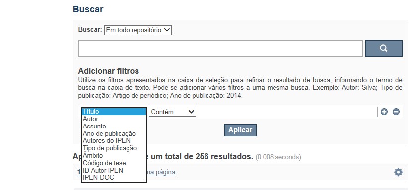
A opção Busca avançada utiliza os conectores da lógica boleana, é o melhor recurso para combinar chaves de busca e obter documentos relevantes à sua pesquisa, utilize os filtros apresentados na caixa de seleção para refinar o resultado de busca. Pode-se adicionar vários filtros a uma mesma busca.
Exemplo:
Buscar os artigos apresentados em um evento internacional de 2015, sobre loss of coolant, do autor Maprelian.
Autor: Maprelian
Título: loss of coolant
Tipo de publicação: Texto completo de evento
Ano de publicação: 2015
✔ Para indexação dos documentos é utilizado o Thesaurus do INIS, especializado na área nuclear e utilizado em todos os países membros da International Atomic Energy Agency – IAEA , por esse motivo, utilize os termos de busca de assunto em inglês; isto não exclui a busca livre por palavras, apenas o resultado pode não ser tão relevante ou pertinente.
✔ 95% do RD apresenta o texto completo do documento com livre acesso, para aqueles que apresentam o ![]() significa que e o documento está sujeito as leis de direitos autorais, solicita-se nesses casos contatar a Biblioteca do IPEN,
bibl@ipen.br
.
significa que e o documento está sujeito as leis de direitos autorais, solicita-se nesses casos contatar a Biblioteca do IPEN,
bibl@ipen.br
.
✔ Ao efetuar a busca por um autor o RD apresentará uma relação de todos os trabalhos depositados no RD. No lado direito da tela são apresentados os coautores com o número de trabalhos produzidos em conjunto bem como os assuntos abordados e os respectivos anos de publicação agrupados.
✔ O RD disponibiliza um quadro estatístico de produtividade, onde é possível visualizar o número dos trabalhos agrupados por tipo de coleção, a medida que estão sendo depositados no RD.
✔ Na página inicial nas referências são sinalizados todos os autores IPEN, ao clicar nesse símbolo ![]() será aberta uma nova página correspondente à aquele autor – trata-se da página do pesquisador.
será aberta uma nova página correspondente à aquele autor – trata-se da página do pesquisador.
✔ Na página do pesquisador, é possível verificar, as variações do nome, a relação de todos os trabalhos com texto completo bem como um quadro resumo numérico; há links para o Currículo Lattes e o Google Acadêmico ( quando esse for informado).
ATENÇÃO!
ESTE TEXTO "AJUDA" ESTÁ SUJEITO A ATUALIZAÇÕES CONSTANTES, A MEDIDA QUE NOVAS FUNCIONALIDADES E RECURSOS DE BUSCA FOREM SENDO DESENVOLVIDOS PELAS EQUIPES DA BIBLIOTECA E DA INFORMÁTICA.
O gerenciamento do Repositório está a cargo da Biblioteca do IPEN. Constam neste RI, até o presente momento 20.950 itens que tanto podem ser artigos de periódicos ou de eventos nacionais e internacionais, dissertações e teses, livros, capítulo de livros e relatórios técnicos. Para participar do RI-IPEN é necessário que pelo menos um dos autores tenha vínculo acadêmico ou funcional com o Instituto. Nesta primeira etapa de funcionamento do RI, a coleta das publicações é realizada periodicamente pela equipe da Biblioteca do IPEN, extraindo os dados das bases internacionais tais como a Web of Science, Scopus, INIS, SciElo além de verificar o Currículo Lattes. O RI-IPEN apresenta também um aspecto inovador no seu funcionamento. Por meio de metadados específicos ele está vinculado ao sistema de gerenciamento das atividades do Plano Diretor anual do IPEN (SIGEPI). Com o objetivo de fornecer dados numéricos para a elaboração dos indicadores da Produção Cientifica Institucional, disponibiliza uma tabela estatística registrando em tempo real a inserção de novos itens. Foi criado um metadado que contém um número único para cada integrante da comunidade científica do IPEN. Esse metadado se transformou em um filtro que ao ser acionado apresenta todos os trabalhos de um determinado autor independente das variáveis na forma de citação do seu nome.
A elaboração do projeto do RI do IPEN foi iniciado em novembro de 2013, colocado em operação interna em julho de 2014 e disponibilizado na Internet em junho de 2015. Utiliza o software livre Dspace, desenvolvido pelo Massachusetts Institute of Technology (MIT). Para descrição dos metadados adota o padrão Dublin Core. É compatível com o Protocolo de Arquivos Abertos (OAI) permitindo interoperabilidade com repositórios de âmbito nacional e internacional.
1. Portaria IPEN-CNEN/SP nº 387, que estabeleceu os princípios que nortearam a criação do RDI, clique aqui.
2. A experiência do Instituto de Pesquisas Energéticas e Nucleares (IPEN-CNEN/SP) na criação de um Repositório Digital Institucional – RDI, clique aqui.
O Repositório Digital do IPEN é um equipamento institucional de acesso aberto, criado com o objetivo de reunir, preservar, disponibilizar e conferir maior visibilidade à Produção Científica publicada pelo Instituto, desde sua criação em 1956.
Operando, inicialmente como uma base de dados referencial o Repositório foi disponibilizado na atual plataforma, em junho de 2015. No Repositório está disponível o acesso ao conteúdo digital de artigos de periódicos, eventos, nacionais e internacionais, livros, capítulos, dissertações, teses e relatórios técnicos.
A elaboração do projeto do RI do IPEN foi iniciado em novembro de 2013, colocado em operação interna em julho de 2014 e disponibilizado na Internet em junho de 2015. Utiliza o software livre Dspace, desenvolvido pelo Massachusetts Institute of Technology (MIT). Para descrição dos metadados adota o padrão Dublin Core. É compatível com o Protocolo de Arquivos Abertos (OAI) permitindo interoperabilidade com repositórios de âmbito nacional e internacional.
O gerenciamento do Repositório está a cargo da Biblioteca do IPEN. Constam neste RI, até o presente momento 20.950 itens que tanto podem ser artigos de periódicos ou de eventos nacionais e internacionais, dissertações e teses, livros, capítulo de livros e relatórios técnicos. Para participar do RI-IPEN é necessário que pelo menos um dos autores tenha vínculo acadêmico ou funcional com o Instituto. Nesta primeira etapa de funcionamento do RI, a coleta das publicações é realizada periodicamente pela equipe da Biblioteca do IPEN, extraindo os dados das bases internacionais tais como a Web of Science, Scopus, INIS, SciElo além de verificar o Currículo Lattes. O RI-IPEN apresenta também um aspecto inovador no seu funcionamento. Por meio de metadados específicos ele está vinculado ao sistema de gerenciamento das atividades do Plano Diretor anual do IPEN (SIGEPI). Com o objetivo de fornecer dados numéricos para a elaboração dos indicadores da Produção Cientifica Institucional, disponibiliza uma tabela estatística registrando em tempo real a inserção de novos itens. Foi criado um metadado que contém um número único para cada integrante da comunidade científica do IPEN. Esse metadado se transformou em um filtro que ao ser acionado apresenta todos os trabalhos de um determinado autor independente das variáveis na forma de citação do seu nome.