Navegação IPEN por Revista "Remote Sensing"
- Página inicial
- →
- IPEN
- →
- Navegação IPEN por Revista
- Sobre
- Perfil Técnico
- Política de funcionamento
- Ajuda
- Apresentação
Navegação IPEN por Revista "Remote Sensing"
Itens para a visualização no momento 1-4 de 4
-
XIAO, DA; WANG, NANCHAO; SHEN, XUE; LANDULFO, EDUARDO
 ; ZHONG, TIANFEN; LIU, DONG. Development of ZJU high-spectral-resolution lidar for aerosol and cloud: extinction retrieval.
Remote Sensing,
v. 12,
n. 18,
p. 1-18,
2020.
DOI:
10.3390/rs12183047
Abstract:
The retrieval of the extinction coefficients of aerosols and clouds without assumptions is the most important advantage of the high-spectral-resolution lidar (HSRL). The standard method to retrieve the extinction coefficient from HSRL signals depends heavily on the signal-to-noise ratio (SNR). In this work, an iterative image reconstruction (IIR) method is proposed for the retrieval of the aerosol extinction coefficient based on HSRL data, this proposed method manages to minimize the difference between the reconstructed and raw signals based on reasonable estimates of the lidar ratio. To avoid the ill-posed solution, a regularization method is adopted to reconstruct the lidar signals in the IIR method. The results from Monte-Carlo (MC) simulations applying both standard and IIR methods are compared and these comparisons demonstrate that the extinction coefficient and the lidar ratio retrieved by the IIR method have smaller root mean square error (RMSE) and relative bias values than the standard method. A case study of measurements made by Zhejiang University (ZJU) HSRL is presented, and their results show that the IIR method not only obtains a finer structure of the aerosol layer under the condition of low SNR, but it is also able to retrieve more reasonable values of the lidar ratio.
; ZHONG, TIANFEN; LIU, DONG. Development of ZJU high-spectral-resolution lidar for aerosol and cloud: extinction retrieval.
Remote Sensing,
v. 12,
n. 18,
p. 1-18,
2020.
DOI:
10.3390/rs12183047
Abstract:
The retrieval of the extinction coefficients of aerosols and clouds without assumptions is the most important advantage of the high-spectral-resolution lidar (HSRL). The standard method to retrieve the extinction coefficient from HSRL signals depends heavily on the signal-to-noise ratio (SNR). In this work, an iterative image reconstruction (IIR) method is proposed for the retrieval of the aerosol extinction coefficient based on HSRL data, this proposed method manages to minimize the difference between the reconstructed and raw signals based on reasonable estimates of the lidar ratio. To avoid the ill-posed solution, a regularization method is adopted to reconstruct the lidar signals in the IIR method. The results from Monte-Carlo (MC) simulations applying both standard and IIR methods are compared and these comparisons demonstrate that the extinction coefficient and the lidar ratio retrieved by the IIR method have smaller root mean square error (RMSE) and relative bias values than the standard method. A case study of measurements made by Zhejiang University (ZJU) HSRL is presented, and their results show that the IIR method not only obtains a finer structure of the aerosol layer under the condition of low SNR, but it is also able to retrieve more reasonable values of the lidar ratio.
Palavras-Chave: optical radar; aerosols; monte carlo method; signal-to-noise ratio; iterative methods; image processing; climatic change; scattering
. Development of ZJU high-spectral-resolution lidar for aerosol and cloud: extinction retrieval. Remote Sensing, v. 12, n. 18, p. 1-18, 2020. DOI: 10.3390/rs12183047. Disponível em: http://200.136.52.105/handle/123456789/31652. Acesso em: $DATA.Como referenciar este itemEsta referência é gerada automaticamente de acordo com as normas do estilo IPEN/SP (ABNT NBR 6023) e recomenda-se uma verificação final e ajustes caso necessário.

-
LOPES, FABIO J. da S.
; CARVALHO, SILVANIA A.; CATALANI, FERNANDO; SILVA, JONATAN J. da
; ALMEIDA, ROGERIO M. de; RIBEIRO, FABIO de J.; FELLOWS, CARLOS E.; LANDULFO, EDUARDO
; MENEGATTI, CARLOS R.; PEIXOTO, CARLOS J.T.. First lidar campaign in the industrial sites of Volta Redonda-RJ and Lorena-SP, Brazil.
Remote Sensing,
v. 14,
n. 7,
p. 1-21,
2022.
DOI:
10.3390/rs14071675
Abstract:
We report on the first aerosol profiling campaign in the Paraíba valley, a hub connecting
the region between the two largest Brazilian metropolitan areas, São Paulo and Rio de Janeiro. São
Paulo Sanitation Technology Company (CETESB) air quality and Cloud-Aerosol Lidar and Infrared
Pathfinder Satellite Observations (CALIPSO) data show homogeneous behavior of the atmosphere
throughout the region. A more detailed description of the particulate material in the local atmosphere,
including its temporal dependence, can be obtained by using ground-based lidars. Measurements
were carried out with a backscatter lidar system in two industrial cities, Volta Redonda and Lorena.
The aerosol backscatter profiles present several peaks at different altitudes, indicating the presence of
aerosol in several atmospheric layers. In addition, The Hybrid Single Particle Lagrangian Integrated
Trajectory (HYSPLIT) air-mass back-trajectories indicate a possible detection of long-range aerosol
transported from biomass burning areas of South America. The present study emphasizes the
importance of investigating and monitoring the emission of particulate matter at this important hub
connection between two dense populated regions of Brazil.
Palavras-Chave: optical radar; satellites; aerosol monitoring; atmospheres; industrial wastes; pollution
. First lidar campaign in the industrial sites of Volta Redonda-RJ and Lorena-SP, Brazil. Remote Sensing, v. 14, n. 7, p. 1-21, 2022. DOI: 10.3390/rs14071675. Disponível em: http://repositorio.ipen.br/handle/123456789/33210. Acesso em: $DATA.Como referenciar este itemEsta referência é gerada automaticamente de acordo com as normas do estilo IPEN/SP (ABNT NBR 6023) e recomenda-se uma verificação final e ajustes caso necessário.
-
BENCHERIF, HASSAN; BÈGUE, NELSON; PINHEIRO, DAMARIS K.; DU PREEZ, DAVID J.; CADET, JEAN-MAURICE; LOPES, FABIO J. da S.
; SHIKWAMBANA, LERATO; LANDULFO, EDUARDO
; VESCOVINI, THOMAS; LABUSCHAGNE, CASPER; SILVA, JONATAN J.
; ANABOR, VAGNER; COHEUR, PIERRE-FRANÇOIS; MBATHA, NKANYISO; HADJI-LAZARO, JULIETTE; SIVAKUMAR, VENKATARAMAN; CLERBAUX, CATHY. Investigating the long-range transport of aerosol plumes following the Amazon fires (August 2019): a multi-instrumental approach from ground-based and satellite observations.
Remote Sensing,
v. 12,
n. 22,
p. 1-18,
2020.
DOI:
10.3390/rs12223846
Abstract:
Despite a number of studies on biomass burning (BB) emissions in the atmosphere, observation of the associated aerosols and pollutants requires continuous efforts. Brazil, and more broadly Latin America, is one of the most important seasonal sources of BB, particularly in the Amazon region. Uncertainty about aerosol loading in the source regions is a limiting factor in terms of understanding the role of aerosols in climate modelling. In the present work, we investigated the Amazon BB episode that occurred during August 2019 and made the international headlines, especially when the smoke plumes plunged distant cities such as São Paulo into darkness. Here, we used satellite and ground-based observations at different locations to investigate the long-range transport of aerosol plumes generated by the Amazon fires during the study period. The monitoring of BB activity was carried out using fire related pixel count from the moderate resolution imaging spectroradiometer (MODIS) onboard the Aqua and Terra platforms, while the distribution of carbon monoxide (CO) concentrations and total columns were obtained from the infrared atmospheric sounding interferometer (IASI) onboard the METOP-A and METOP-B satellites. In addition, AERONET sun-photometers as well as the MODIS instrument made aerosol optical depth (AOD) measurements over the study region. Our datasets are consistent with each other and highlight AOD and CO variations and long-range transport of the fire plume from the source regions in the Amazon basin. We used the Lagrangian transport model FLEXPART (FLEXible PARTicle) to simulate backward dispersion, which showed good agreement with satellite and ground measurements observed over the study area. The increase in Rossby wave activity during the 2019 austral winter the Southern Hemisphere may have contributed to increasing the efficiency of large-scale transport of aerosol plumes generated by the Amazon fires during the study period.
Palavras-Chave: biomass; fires; aerosols; aerosol wastes; air transport; carbon monoxide; satellites; plumes; air pollution; amazon river
. Investigating the long-range transport of aerosol plumes following the Amazon fires (August 2019): a multi-instrumental approach from ground-based and satellite observations. Remote Sensing, v. 12, n. 22, p. 1-18, 2020. DOI: 10.3390/rs12223846. Disponível em: http://repositorio.ipen.br/handle/123456789/31815. Acesso em: $DATA.Como referenciar este itemEsta referência é gerada automaticamente de acordo com as normas do estilo IPEN/SP (ABNT NBR 6023) e recomenda-se uma verificação final e ajustes caso necessário.
-
LOPES, FABIO J.S.
; SILVA, JONATAN J.
; MARRERO, JUAN C.A.; TAHA, GHASSAN; LANDULFO, EDUARDO
. Synergetic aerosol layer observation after the 2015 Calbuco volcanic eruption event.
Remote Sensing,
v. 11,
n. 2,
p. 1-22,
2019.
DOI:
10.3390/rs11020195
Abstract:
On 22 April 2015, the Calbuco volcano in Chile (Lat: 41.33 S, Long: 72.62 W) erupted
after 43 years of inactivity followed by a great amount of aerosol injection into the atmosphere.
The pyroclastic material dispersed into the atmosphere posed a potential threat to aviation traffic
and air quality over affected a large area. The plumes and debris spread from its location to
Patagonian and Pampean regions, reaching the Atlantic and Pacific Oceans and neighboring
countries, such as Argentina, Brazil and Uruguay, driven by the westerly winds at these latitudes.
The presence of volcanic aerosol layers could be identified promptly at the proximities of Calbuco
and afterwards by remote sensing using satellites and lidars in the path of the dispersed aerosols.
The Cloud-Aerosol Lidar and Pathfinder Satellite Observations (CALIPSO), Moderate Resolution
Imaging Spectroradiometer (MODIS) on board of AQUA/TERRA satellites and Ozone Mapping and
Profiler Suite (OMPS) on board of Suomi National Polar-orbiting Partnership (Suomi NPP) satellite
were the space platforms used to track the injected layers and a multi-channel lidar system from Latin
America Lidar Network (LALINET) SPU Lidar station in South America allowed us to get the spatial
and temporal distribution of Calbuco ashes after its occurrence. The SPU lidar stations co-located
Aerosol Robotic Network (AERONET) sunphotometers to help in the optical characterization. Here,
we present the volcanic layer transported over São Paulo area and the detection of aerosol plume
between 18 and 20 km. The path traveled by the volcanic aerosol to reach the Metropolitan Area
of São Paulo (MASP) was tracked by CALIPSO and the aerosol optical and geometrical properties
were retrieved at some points to monitor the plume evolution. Total attenuated backscatter profile at
532 nm obtained by CALIPSO revealed the height range extension of the aerosol plume between 18
and 20 km and are in agreement with SPU lidar range corrected signal at 532 nm. The daily evolution
of Aerosol Optical Depth (AOD) at 532 and 355 nm, retrieved from AERONET sunphotometer,
showed a substantial increasing on 27 April, the day of the volcanic plume detection at Metropolitan
Area of São Paulo (MASP), achieving values of 0.33 0.16 and 0.22 0.09 at 355 and 532 nm,
respectively. AERONET aerosol size distribution was dominated by fine mode aerosol over coarse
mode, especially on 27 and 28 April. The space and time coincident aerosol extinction profiles from
SPU lidar station and OMPS LP from the Calbuco eruption conducted on 27 April agreed on the
double layer structure. The main objective of this study was the application of the transmittance
method, using the Platt formalism, to calculate the optical and physical properties of volcanic plume,
i.e., aerosol bottom and top altitude, the aerosol optical depth and lidar ratio. The aerosol plume was
detected between 18 and 19.3 km, with AOD value of 0.159 at 532 nm and Ånsgtröm exponent of
0.61 0.58. The lidar ratio retrieved was 76 27 sr and 63 21 sr at 532 and 355 nm, respectively. Considering the values of these parameters, the Calbuco volcanic aerosol layers could be classified as
sulfates with some ash type.
Palavras-Chave: volcanoes; ashes; aerosols; boundary layers; atmospheric circulation; optical radar; south america; air quality
. Synergetic aerosol layer observation after the 2015 Calbuco volcanic eruption event. Remote Sensing, v. 11, n. 2, p. 1-22, 2019. DOI: 10.3390/rs11020195. Disponível em: http://repositorio.ipen.br/handle/123456789/30036. Acesso em: $DATA.Como referenciar este itemEsta referência é gerada automaticamente de acordo com as normas do estilo IPEN/SP (ABNT NBR 6023) e recomenda-se uma verificação final e ajustes caso necessário.
Itens para a visualização no momento 1-4 de 4
Buscar no repositório
Navegar
Minha conta
Visualizar
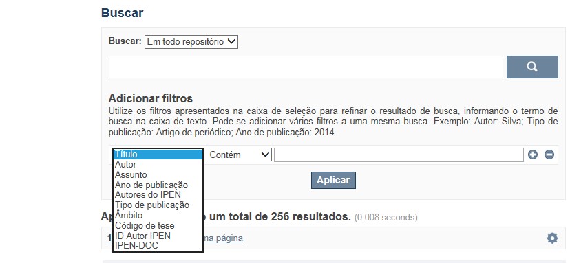
A pesquisa no RD utiliza os recursos de busca da maioria das bases de dados. No entanto algumas dicas podem auxiliar para obter um resultado mais pertinente.
✔ É possível efetuar a busca de um autor ou um termo em todo o RD, por meio do Buscar no Repositório , isto é, o termo solicitado será localizado em qualquer campo do RD. No entanto esse tipo de pesquisa não é recomendada a não ser que se deseje um resultado amplo e generalizado.
✔ A pesquisa apresentará melhor resultado selecionando um dos filtros disponíveis em Navegar
✔ Os filtros disponíveis em Navegar tais como: Coleções, Ano de publicação, Títulos, Assuntos, Autores, Revista, Tipo de publicação são autoexplicativos. O filtro, Autores IPEN apresenta uma relação com os autores vinculados ao IPEN; o ID Autor IPEN diz respeito ao número único de identificação de cada autor constante no RD e sob o qual estão agrupados todos os seus trabalhos independente das variáveis do seu nome; Tipo de acesso diz respeito à acessibilidade do documento, isto é , sujeito as leis de direitos autorais, ID RT apresenta a relação dos relatórios técnicos, restritos para consulta das comunidades indicadas.
A opção Busca avançada utiliza os conectores da lógica boleana, é o melhor recurso para combinar chaves de busca e obter documentos relevantes à sua pesquisa, utilize os filtros apresentados na caixa de seleção para refinar o resultado de busca. Pode-se adicionar vários filtros a uma mesma busca.
Exemplo:
Buscar os artigos apresentados em um evento internacional de 2015, sobre loss of coolant, do autor Maprelian.
Autor: Maprelian
Título: loss of coolant
Tipo de publicação: Texto completo de evento
Ano de publicação: 2015
✔ Para indexação dos documentos é utilizado o Thesaurus do INIS, especializado na área nuclear e utilizado em todos os países membros da International Atomic Energy Agency – IAEA , por esse motivo, utilize os termos de busca de assunto em inglês; isto não exclui a busca livre por palavras, apenas o resultado pode não ser tão relevante ou pertinente.
✔ 95% do RD apresenta o texto completo do documento com livre acesso, para aqueles que apresentam o ![]() significa que e o documento está sujeito as leis de direitos autorais, solicita-se nesses casos contatar a Biblioteca do IPEN,
bibl@ipen.br
.
significa que e o documento está sujeito as leis de direitos autorais, solicita-se nesses casos contatar a Biblioteca do IPEN,
bibl@ipen.br
.
✔ Ao efetuar a busca por um autor o RD apresentará uma relação de todos os trabalhos depositados no RD. No lado direito da tela são apresentados os coautores com o número de trabalhos produzidos em conjunto bem como os assuntos abordados e os respectivos anos de publicação agrupados.
✔ O RD disponibiliza um quadro estatístico de produtividade, onde é possível visualizar o número dos trabalhos agrupados por tipo de coleção, a medida que estão sendo depositados no RD.
✔ Na página inicial nas referências são sinalizados todos os autores IPEN, ao clicar nesse símbolo ![]() será aberta uma nova página correspondente à aquele autor – trata-se da página do pesquisador.
será aberta uma nova página correspondente à aquele autor – trata-se da página do pesquisador.
✔ Na página do pesquisador, é possível verificar, as variações do nome, a relação de todos os trabalhos com texto completo bem como um quadro resumo numérico; há links para o Currículo Lattes e o Google Acadêmico ( quando esse for informado).
ATENÇÃO!
ESTE TEXTO "AJUDA" ESTÁ SUJEITO A ATUALIZAÇÕES CONSTANTES, A MEDIDA QUE NOVAS FUNCIONALIDADES E RECURSOS DE BUSCA FOREM SENDO DESENVOLVIDOS PELAS EQUIPES DA BIBLIOTECA E DA INFORMÁTICA.
O gerenciamento do Repositório está a cargo da Biblioteca do IPEN. Constam neste RI, até o presente momento 20.950 itens que tanto podem ser artigos de periódicos ou de eventos nacionais e internacionais, dissertações e teses, livros, capítulo de livros e relatórios técnicos. Para participar do RI-IPEN é necessário que pelo menos um dos autores tenha vínculo acadêmico ou funcional com o Instituto. Nesta primeira etapa de funcionamento do RI, a coleta das publicações é realizada periodicamente pela equipe da Biblioteca do IPEN, extraindo os dados das bases internacionais tais como a Web of Science, Scopus, INIS, SciElo além de verificar o Currículo Lattes. O RI-IPEN apresenta também um aspecto inovador no seu funcionamento. Por meio de metadados específicos ele está vinculado ao sistema de gerenciamento das atividades do Plano Diretor anual do IPEN (SIGEPI). Com o objetivo de fornecer dados numéricos para a elaboração dos indicadores da Produção Cientifica Institucional, disponibiliza uma tabela estatística registrando em tempo real a inserção de novos itens. Foi criado um metadado que contém um número único para cada integrante da comunidade científica do IPEN. Esse metadado se transformou em um filtro que ao ser acionado apresenta todos os trabalhos de um determinado autor independente das variáveis na forma de citação do seu nome.
A elaboração do projeto do RI do IPEN foi iniciado em novembro de 2013, colocado em operação interna em julho de 2014 e disponibilizado na Internet em junho de 2015. Utiliza o software livre Dspace, desenvolvido pelo Massachusetts Institute of Technology (MIT). Para descrição dos metadados adota o padrão Dublin Core. É compatível com o Protocolo de Arquivos Abertos (OAI) permitindo interoperabilidade com repositórios de âmbito nacional e internacional.
1. Portaria IPEN-CNEN/SP nº 387, que estabeleceu os princípios que nortearam a criação do RDI, clique aqui.
2. A experiência do Instituto de Pesquisas Energéticas e Nucleares (IPEN-CNEN/SP) na criação de um Repositório Digital Institucional – RDI, clique aqui.
O Repositório Digital do IPEN é um equipamento institucional de acesso aberto, criado com o objetivo de reunir, preservar, disponibilizar e conferir maior visibilidade à Produção Científica publicada pelo Instituto, desde sua criação em 1956.
Operando, inicialmente como uma base de dados referencial o Repositório foi disponibilizado na atual plataforma, em junho de 2015. No Repositório está disponível o acesso ao conteúdo digital de artigos de periódicos, eventos, nacionais e internacionais, livros, capítulos, dissertações, teses e relatórios técnicos.
A elaboração do projeto do RI do IPEN foi iniciado em novembro de 2013, colocado em operação interna em julho de 2014 e disponibilizado na Internet em junho de 2015. Utiliza o software livre Dspace, desenvolvido pelo Massachusetts Institute of Technology (MIT). Para descrição dos metadados adota o padrão Dublin Core. É compatível com o Protocolo de Arquivos Abertos (OAI) permitindo interoperabilidade com repositórios de âmbito nacional e internacional.
O gerenciamento do Repositório está a cargo da Biblioteca do IPEN. Constam neste RI, até o presente momento 20.950 itens que tanto podem ser artigos de periódicos ou de eventos nacionais e internacionais, dissertações e teses, livros, capítulo de livros e relatórios técnicos. Para participar do RI-IPEN é necessário que pelo menos um dos autores tenha vínculo acadêmico ou funcional com o Instituto. Nesta primeira etapa de funcionamento do RI, a coleta das publicações é realizada periodicamente pela equipe da Biblioteca do IPEN, extraindo os dados das bases internacionais tais como a Web of Science, Scopus, INIS, SciElo além de verificar o Currículo Lattes. O RI-IPEN apresenta também um aspecto inovador no seu funcionamento. Por meio de metadados específicos ele está vinculado ao sistema de gerenciamento das atividades do Plano Diretor anual do IPEN (SIGEPI). Com o objetivo de fornecer dados numéricos para a elaboração dos indicadores da Produção Cientifica Institucional, disponibiliza uma tabela estatística registrando em tempo real a inserção de novos itens. Foi criado um metadado que contém um número único para cada integrante da comunidade científica do IPEN. Esse metadado se transformou em um filtro que ao ser acionado apresenta todos os trabalhos de um determinado autor independente das variáveis na forma de citação do seu nome.