Navegação Periódicos - Artigos por autor "10204"
- Página inicial
- →
- IPEN
- →
- Periódicos - Artigos
- →
- Navegação Periódicos - Artigos por autor
- Sobre
- Perfil Técnico
- Política de funcionamento
- Ajuda
- Apresentação
Navegação Periódicos - Artigos por autor "10204"
Itens para a visualização no momento 1-16 de 16
-
CASQUERO-VERA, J.A.; LYAMANI, H.; TITOS, G.; MOREIRA, G. de A.
 ; BENAVENT-OLTRA, J.A.; CONTE, M.; CONTINI, D.; JARVI, L.; OLMO-REYES, F.J.; ALADOS-ARBOLEDAS, L.. Aerosol number fluxes and concentrations over a southern European urban area.
Atmospheric Environment,
v. 269,
p. 1-10,
2022.
DOI:
10.1016/j.atmosenv.2021.118849
Abstract:
Although cities are an important source of aerosol particles, aerosol number flux measurements over urban areas are scarce. These measurements are however important as they can allow us to identify the different sources/sinks of aerosol particles and quantify their emission contributions. Therefore, they can help us to understand the aerosol impacts on human health and climate, and to design effective mitigation strategies through the reduction of urban aerosol emissions. In this work we analyze the aerosol number concentrations and fluxes for particles with diameters larger than 2.5 nm measured by eddy covariance technique at an urban area (Granada city, Spain) from November 2016 to April 2018. This is the first study of particle number flux in an urban area in the Iberian Peninsula and is one of the few current studies that report long-term aerosol number flux measurements. The results suggest that, on average, Granada urban area acted as a net source for atmospheric aerosol particles with median particle number flux of 150 × 106 m−2 s−1. Downward negative fluxes were observed in only 12% of the analyzed data, and most of them were observed during high aerosol load conditions. Both aerosol number fluxes and concentrations were maximum in winter and 50% larger than those measured in summer due to the increased emissions from domestic heating, burning of residual agricultural waste in the agricultural area surrounding the site, as well as to the lower aerosol dilution effects during winter. The analysis of the seasonal diurnal variability of the aerosol number concentration revealed the significant impact of traffic emissions on aerosol population over Granada urban area in all seasons. It also shows the impact of domestic heating and agricultural waste burning emissions in winter as well as the influence of new particle formation processes in summer and spring seasons. Closer analysis by wind sector demonstrated that both aerosol concentrations and fluxes from urban sector (where high density of anthropogenic sources is located) were lower than those from rural sector (which includes agricultural area but also the main highway of the city). This evidences the strong impact of aerosol emissions from traffic circulating on the highway on aerosol population over our measurement site.
; BENAVENT-OLTRA, J.A.; CONTE, M.; CONTINI, D.; JARVI, L.; OLMO-REYES, F.J.; ALADOS-ARBOLEDAS, L.. Aerosol number fluxes and concentrations over a southern European urban area.
Atmospheric Environment,
v. 269,
p. 1-10,
2022.
DOI:
10.1016/j.atmosenv.2021.118849
Abstract:
Although cities are an important source of aerosol particles, aerosol number flux measurements over urban areas are scarce. These measurements are however important as they can allow us to identify the different sources/sinks of aerosol particles and quantify their emission contributions. Therefore, they can help us to understand the aerosol impacts on human health and climate, and to design effective mitigation strategies through the reduction of urban aerosol emissions. In this work we analyze the aerosol number concentrations and fluxes for particles with diameters larger than 2.5 nm measured by eddy covariance technique at an urban area (Granada city, Spain) from November 2016 to April 2018. This is the first study of particle number flux in an urban area in the Iberian Peninsula and is one of the few current studies that report long-term aerosol number flux measurements. The results suggest that, on average, Granada urban area acted as a net source for atmospheric aerosol particles with median particle number flux of 150 × 106 m−2 s−1. Downward negative fluxes were observed in only 12% of the analyzed data, and most of them were observed during high aerosol load conditions. Both aerosol number fluxes and concentrations were maximum in winter and 50% larger than those measured in summer due to the increased emissions from domestic heating, burning of residual agricultural waste in the agricultural area surrounding the site, as well as to the lower aerosol dilution effects during winter. The analysis of the seasonal diurnal variability of the aerosol number concentration revealed the significant impact of traffic emissions on aerosol population over Granada urban area in all seasons. It also shows the impact of domestic heating and agricultural waste burning emissions in winter as well as the influence of new particle formation processes in summer and spring seasons. Closer analysis by wind sector demonstrated that both aerosol concentrations and fluxes from urban sector (where high density of anthropogenic sources is located) were lower than those from rural sector (which includes agricultural area but also the main highway of the city). This evidences the strong impact of aerosol emissions from traffic circulating on the highway on aerosol population over our measurement site.
Palavras-Chave: urban areas; aerosols; concentration ratio; atmospheres; particles; eddy currents; data covariances
. Aerosol number fluxes and concentrations over a southern European urban area. Atmospheric Environment, v. 269, p. 1-10, 2022. DOI: 10.1016/j.atmosenv.2021.118849. Disponível em: http://repositorio.ipen.br/handle/123456789/32956. Acesso em: $DATA.Como referenciar este itemEsta referência é gerada automaticamente de acordo com as normas do estilo IPEN/SP (ABNT NBR 6023) e recomenda-se uma verificação final e ajustes caso necessário.

-
MOREIRA, GREGORI de A.
; LOPES, FABIO J. da S.
; GUERRERO-RASCADO, JUAN L.; SILVA, JONATAN J. da
; GOMES, ANTONIO A.
; LANDULFO, EDUARDO
; ALADOS-ARBOLEDAS, LUCAS. Analyzing the atmospheric boundary layer using high-order moments obtained from multiwavelength lidar data: impact of wavelength choice.
Atmospheric Measurement Techniques,
v. 12,
n. 8,
p. 4261-4276,
2019.
DOI:
10.5194/amt-12-4261-2019
Abstract:
The lowest region of the troposphere is a turbulent
layer known as the atmospheric boundary layer (ABL)
and characterized by high daily variability due to the influence
of surface forcings. This is the reason why detecting
systems with high spatial and temporal resolution, such as
lidar, have been widely applied for researching this region.
In this paper, we present a comparative analysis on the use
of lidar-backscattered signals at three wavelengths (355, 532
and 1064 nm) to study the ABL by investigating the highorder
moments, which give us information about the ABL
height (derived by the variance method), aerosol layer movement
(skewness) and mixing conditions (kurtosis) at several
heights. Previous studies have shown that the 1064 nm wavelength,
due to the predominance of particle signature in the
total backscattered atmospheric signal and practically null
presence of molecular signal (which can represent noise in
high-order moments), provides an appropriate description of
the turbulence field, and thus in this study it was considered
a reference. We analyze two case studies that show us that
the backscattered signal at 355 nm, even after applying some
corrections, has a limited applicability for turbulence studies
using the proposed methodology due to the strong contribution
of the molecular signature to the total backscatter signal.
This increases the noise associated with the high-order
profiles and, consequently, generates misinformation. On the
other hand, the information on the turbulence field derived
from the backscattered signal at 532 nm is similar to that obtained at 1064 nm due to the appropriate attenuation of the
noise, generated by molecular component of backscattered
signal by the application of the corrections proposed.
Palavras-Chave: troposphere; optical radar; boundary layers; atmospheres; aerosols; turbulence; air quality; monitoring
. Analyzing the atmospheric boundary layer using high-order moments obtained from multiwavelength lidar data: impact of wavelength choice. Atmospheric Measurement Techniques, v. 12, n. 8, p. 4261-4276, 2019. DOI: 10.5194/amt-12-4261-2019. Disponível em: http://repositorio.ipen.br/handle/123456789/30379. Acesso em: $DATA.Como referenciar este itemEsta referência é gerada automaticamente de acordo com as normas do estilo IPEN/SP (ABNT NBR 6023) e recomenda-se uma verificação final e ajustes caso necessário.
-
MOREIRA, GREGORI de A.
; CACHEFFO, ALEXANDRE
; ANDRADE, IZABEL da S.
; LOPES, FABIO JULIANO da S.
; GOMES, ANTONIO A.
; LANDULFO, EDUARDO
. Analyzing the influence of vehicular traffic on the concentration of pollutants in the city of São Paulo: an approach based on pandemic SARS-CoV-2 data and deep learning.
Atmosphere,
v. 14,
n. 10,
p. 1-16,
2023.
DOI:
10.3390/atmos14101578
Abstract:
This study employs surface and remote sensing data jointly with deep learning techniques
to examine the influence of vehicular traffic in the seasonal patterns of CO, NO2
, PM2.5, and PM10
concentrations in the São Paulo municipality, as the period of physical distancing (March 2020 to
December 2021), due to SARS-CoV-2 pandemic and the resumption of activities, made it possible to
observe significant variations in the flow of vehicles in the city of São Paulo. Firstly, an analysis of the
planetary boundary layer height and ventilation coefficient was performed to identify the seasons’
patterns of pollution dispersion. Then, the variations (from 2018 to 2021) of the seasonal average
values of air temperature, relative humidity, precipitation, and thermal inversion occurrence/position
were compared to identify possible variations in the patterns of such variables that would justify (or
deny) the occurrence of more favorable conditions for pollutants dispersion. However, no significant
variations were found. Finally, the seasonal average concentrations of the previously mentioned
pollutants were compared from 2018 to 2021, and the daily concentrations observed during the
pandemic period were compared with a model based on an artificial neural network. Regarding the
concentration of pollutants, the primarily sourced from vehicular traffic (CO and NO2
) exhibited
substantial variations, demonstrating an inverse relationship with the rate of social distancing.
In addition, the measured concentrations deviated from the predictive model during periods of
significant social isolation. Conversely, pollutants that were not primarily linked to vehicular sources
(PM2.5 and PM10) exhibited minimal variation from 2018 to 2021; thus, their measured concentration
remained consistent with the prediction model.
Palavras-Chave: urban areas; air pollution; air quality; machine learning; vehicles; coronaviruses
. Analyzing the influence of vehicular traffic on the concentration of pollutants in the city of São Paulo: an approach based on pandemic SARS-CoV-2 data and deep learning. Atmosphere, v. 14, n. 10, p. 1-16, 2023. DOI: 10.3390/atmos14101578. Disponível em: http://repositorio.ipen.br/handle/123456789/34210. Acesso em: $DATA.Como referenciar este itemEsta referência é gerada automaticamente de acordo com as normas do estilo IPEN/SP (ABNT NBR 6023) e recomenda-se uma verificação final e ajustes caso necessário.
-
MOREIRA, GREGORI de A.
; GUERRERO-RASCADO, JUAN L.; BENAVENT-OLTRA, JOSE A.; ORTIZ-AMEZCUA, PABLO; ROMAN, ROBERTO; BEDOYA-VELASQUEZ, ANDRES E.; BRAVO-ARANDA, JUAN A.; REYES, FRANCISCO J.O.; LANDULFO, EDUARDO
; ALADOS-ARBOLEDAS, LUCAS. Analyzing the turbulent planetary boundary layer by remote sensing systems: the Doppler wind lidar, aerosol elastic lidar and microwave radiometer.
Atmospheric Chemistry and Physics,
v. 19,
n. 2,
p. 1263-1280,
2019.
DOI:
10.5194/acp-19-1263-2019
Abstract:
The planetary boundary layer (PBL) is the lowermost
region of troposphere and is endowed with turbulent
characteristics, which can have mechanical and/or thermodynamic
origins. This behavior gives this layer great importance,
mainly in studies about pollutant dispersion and
weather forecasting. However, the instruments usually applied
in studies of turbulence in the PBL have limitations
in spatial resolution (anemometer towers) or temporal resolution
(instrumentation aboard an aircraft). Ground-based
remote sensing, both active and passive, offers an alternative
for studying the PBL. In this study we show the capabilities
of combining different remote sensing systems (microwave
radiometer – MWR, Doppler lidar – DL – and elastic lidar
– EL) for retrieving a detailed picture on the PBL turbulent
features. The statistical moments of the high frequency distributions
of the vertical wind velocity, derived from DL,
and of the backscattered coefficient, derived from EL, are
corrected by two methodologies, namely first lag correction
and 2=3 law correction. The corrected profiles, obtained
from DL data, present small differences when compared with
the uncorrected profiles, showing the low influence of noise
and the viability of the proposed methodology. Concerning
EL, in addition to analyzing the influence of noise, we explore
the use of different wavelengths that usually include
EL systems operated in extended networks, like the European
Aerosol Research Lidar Network (EARLINET), Latin American
Lidar Network (LALINET), NASA Micro-Pulse Lidar
Network (MPLNET) or Skyradiometer Network (SKYNET).
In this way we want to show the feasibility of extending the
capability of existing monitoring networks without strong investments
or changes in their measurements protocols. Two
case studies were analyzed in detail, one corresponding to
a well-defined PBL and another corresponding to a situation
with presence of a Saharan dust lofted aerosol layer
and clouds. In both cases we discuss results provided by the
different instruments showing their complementarity and the
precautions to be applied in the data interpretation. Our study
shows that the use of EL at 532 nm requires a careful correction
of the signal using the first lag time correction in order
to get reliable turbulence information on the PBL.
Palavras-Chave: boundary layers; troposphere; planetary atmospheres; doppler effect; wind; optical radar; monitoring; microwave radiation; radiometers; aerosols; elastic scattering; remote sensing
. Analyzing the turbulent planetary boundary layer by remote sensing systems: the Doppler wind lidar, aerosol elastic lidar and microwave radiometer. Atmospheric Chemistry and Physics, v. 19, n. 2, p. 1263-1280, 2019. DOI: 10.5194/acp-19-1263-2019. Disponível em: http://repositorio.ipen.br/handle/123456789/29929. Acesso em: $DATA.Como referenciar este itemEsta referência é gerada automaticamente de acordo com as normas do estilo IPEN/SP (ABNT NBR 6023) e recomenda-se uma verificação final e ajustes caso necessário.
-
MOREIRA, GREGORI de A.
; OLIVEIRA, AMAURI P. de; CODATO, GEORGIA; SANCHEZ, MACIEL P.; TITO, JANET V.; SILVA, LEONARDO A.H. e; SILVEIRA, LUCAS C. da; SILVA, JONATAN J. da
; LOPES, FABIO J. da S.
; LANDULFO, EDUARDO
. Assessing spatial variation of PBL height and aerosol layer aloft in São Paulo Megacity using simultaneously two lidar during winter 2019.
Atmosphere,
v. 13,
n. 4,
p. 1-16,
2022.
DOI:
10.3390/atmos13040611
Abstract:
This work presents the use of two elastic lidar systems to assess the horizontal variation of
the PBL height (PBLH) and aerosol layer aloft in the São Paulo Megacity. These two lidars performed
simultaneous measurements 10.7 km apart in a highly urbanized and relatively flat area of São Paulo
for two winter months of 2019. The results showed that the PBLH differences display diurnal
variation that depends on the PBL during daytime growth phases. Cloud and sea breeze effects
control most of PBLH variation. In the absence of cloud and sea breeze, the maximum difference
(~300 m) occurs in the rapid development stage and is due to topographic effects. When the PBL
approaches its maximum daily value, it tends to level off with respect to the topography. In addition,
it was presented a method that combines elastic lidar (to detect an aerosol layer) and satellite data
(to classify such a layer from Aerosol Optical Depth (AOD) and Aerosol Index (AI) information) for
the detection of biomass burning events. This methodology demonstrated that the variations caused
by Biomass Burning in AOD and AI enable both the detection of aerosol plumes originating from
biomass burning and the identification of their origin.
Palavras-Chave: boundary layers; earth atmosphere; biomass; burns; urban areas; optical radar
. Assessing spatial variation of PBL height and aerosol layer aloft in São Paulo Megacity using simultaneously two lidar during winter 2019. Atmosphere, v. 13, n. 4, p. 1-16, 2022. DOI: 10.3390/atmos13040611. Disponível em: http://repositorio.ipen.br/handle/123456789/33156. Acesso em: $DATA.Como referenciar este itemEsta referência é gerada automaticamente de acordo com as normas do estilo IPEN/SP (ABNT NBR 6023) e recomenda-se uma verificação final e ajustes caso necessário.
-
MOREIRA, GREGORI de A.
; LOPES, FABIO J. da S.
; GUERRERO-RASCADO, JUAN L.; ORTIZ-AMEZCUA, PABLO; CAZORLA, ALBERTO; OLIVEIRA, AMAURI P. de; LANDULFO, EDUARDO
; ALADOS-ARBOLEDAS, LUCAS. Comparison among the atmospheric boundary layer height estimated from three different tracers.
EPJ Web of Conferences,
v. 237,
p. 1-4,
2020.
DOI:
10.1051/epjconf/202023703009
Abstract:
The Atmospheric Boundary Layer (ABL) is the lowermost part of the troposphere. In this work, we analysed the combination of ABL height estimated continuously by three different remote sensing systems: a ceilometer, a Doppler lidar and a passive Microwave Radiometer, during a summer campaign, which was held in Granada from June to August 2016. This study demonstrates as the combined utilization of remote sensing systems, based on different tracers, can provide detailed information about the height of ABL and their sublayers.
Palavras-Chave: atmospheres; doppler effect; boundary layers; troposphere; optical radar; microwave radiation; radiometers
. Comparison among the atmospheric boundary layer height estimated from three different tracers. EPJ Web of Conferences, v. 237, p. 1-4, 2020. DOI: 10.1051/epjconf/202023703009. Disponível em: http://repositorio.ipen.br/handle/123456789/31470. Acesso em: $DATA.Como referenciar este itemEsta referência é gerada automaticamente de acordo com as normas do estilo IPEN/SP (ABNT NBR 6023) e recomenda-se uma verificação final e ajustes caso necessário.
-
MOREIRA, GREGORI de A.
; ANDRADE, IZABEL da S.
; CACHEFFO, ALEXANDRE
; YOSHIDA, ALEXANDRE C.
; GOMES, ANTONIO A.
; SILVA, JONATAN J. da
; LOPES, FABIO J. da S.
; LANDULFO, EDUARDO
. COVID-19 outbreak and air quality: analyzing the influence of physical distancing and the resumption of activities in São Paulo municipality.
Urban Climate,
v. 37,
p. 1-15,
2021.
DOI:
10.1016/j.uclim.2021.100813
Abstract:
This work compares variations in the concentrations and air quality indexes of the pollutants PM10, PM2.5, CO, and NO2, during the
COVID-19 outbreak in São Paulo Municipality. Such comparisons considered the period of physical distancing (autumn) and the three
first months of economic activities’ resumption (winter). The concentrations and indexes observed in 2020 were compared with their
correspondent values measured in the three preceding years. Also, from a supervised machine learning algorithm, the correspondent
2020 expected values were predicted and used in these comparisons. In order to analyze the influence of meteorological conditions, the
seasons studied were characterized using remote sensing and surface data. The pollutants predominantly emitted by the vehicle fleet
(CO and NO2) had reductions in their concentrations, with values always below the predictions and good air quality indexes. However,
the pollutants whose concentration is less dependent on automotive emissions (PM10 and PM2.5) had high proximity to the predictions
during the autumn and lower values during some periods in winter. This reduction was not enough to avoid days with a moderate air
quality index. The approximation of the average concentrations of PM10, PM2.5, and CO to the prediction, from the second-half August 2020, indicates the influence of activities’ resumption in air quality.
Palavras-Chave: coronaviruses; urban areas; urban populations; emergency plans; air quality; air pollution monitors; pollution sources; optical radar
. COVID-19 outbreak and air quality: analyzing the influence of physical distancing and the resumption of activities in São Paulo municipality. Urban Climate, v. 37, p. 1-15, 2021. DOI: 10.1016/j.uclim.2021.100813. Disponível em: http://repositorio.ipen.br/handle/123456789/32059. Acesso em: $DATA.Como referenciar este itemEsta referência é gerada automaticamente de acordo com as normas do estilo IPEN/SP (ABNT NBR 6023) e recomenda-se uma verificação final e ajustes caso necessário.
-
BENAVENT-OLTRA, JOSE A.; ROMAN, ROBERTO; CASQUERO-VERA, JUAN A.; PEREZ-RAMIREZ, DANIEL; LYAMANI, HASSAN; ORTIZ-AMEZCUA, PABLO; BEDOYA-VELASQUEZ, ANDRES E.; MOREIRA, GREGORI de A.
; BARRETO, AFRICA; LOPATIN, ANTON; FUERTES, DAVID; HERRERA, MILAGROS; TORRES, BENJAMIN; DUBOVIK, OLEG; GUERRERO-RASCADO, JUAN L.; GOLOUB, PHILIPPE; OLMO-REYES, FRANCISCO J.; ALADOS-ARBOLEDAS, LUCAS. Different strategies to retrieve aerosol properties at night-time with the GRASP algorithm.
Atmospheric Chemistry and Physics,
v. 19,
n. 22,
p. 14149-14171,
2019.
DOI:
10.5194/acp-19-14149-2019
Abstract:
This study evaluates the potential of the GRASP
algorithm (Generalized Retrieval of Aerosol and Surface
Properties) to retrieve continuous day-to-night aerosol properties,
both column-integrated and vertically resolved. The
study is focused on the evaluation of GRASP retrievals
during an intense Saharan dust event that occurred during
the Sierra Nevada Lidar aerOsol Profiling Experiment I
(SLOPE I) field campaign. For daytime aerosol retrievals,
we combined the measurements of the ground-based lidar
from EARLINET (European Aerosol Research Lidar
Network) station and sun–sky photometer from AERONET
(Aerosol Robotic Network), both instruments co-located in
Granada (Spain). However, for night-time retrievals three
different combinations of active and passive remote-sensing
measurements are proposed. The first scheme (N0) uses lidar
night-time measurements in combination with the interpolation
of sun–sky daytime measurements. The other two
schemes combine lidar night-time measurements with nighttime
aerosol optical depth obtained by lunar photometry either
using intensive properties of the aerosol retrieved during
sun–sky daytime measurements (N1) or using the Moon aureole
radiance obtained by sky camera images (N2). Evaluations of the columnar aerosol properties retrieved
by GRASP are done versus standard AERONET retrievals.
The coherence of day-to-night evolutions of the different
aerosol properties retrieved by GRASP is also studied. The
extinction coefficient vertical profiles retrieved by GRASP
are compared with the profiles calculated by the Raman
technique at night-time with differences below 30% for all
schemes at 355, 532 and 1064 nm. Finally, the volume concentration
and scattering coefficient retrieved by GRASP at
2500ma.s.l. are evaluated by in situ measurements at this
height at Sierra Nevada Station. The differences between
GRASP and in situ measurements are similar for the different
schemes, with differences below 30% for both volume
concentration and scattering coefficient. In general, for the
scattering coefficient, the GRASP N0 and N1 show better results
than the GRASP N2 schemes, while for volume concentration,
GRASP N2 shows the lowest differences against
in situ measurements (around 10 %) for high aerosol optical
depth values.
Palavras-Chave: algorithms; aerosol monitoring; surface properties; dusts; optical properties; optical radar; deserts; aerosol wastes; raman effect
. Different strategies to retrieve aerosol properties at night-time with the GRASP algorithm. Atmospheric Chemistry and Physics, v. 19, n. 22, p. 14149-14171, 2019. DOI: 10.5194/acp-19-14149-2019. Disponível em: http://repositorio.ipen.br/handle/123456789/30828. Acesso em: $DATA.Como referenciar este itemEsta referência é gerada automaticamente de acordo com as normas do estilo IPEN/SP (ABNT NBR 6023) e recomenda-se uma verificação final e ajustes caso necessário.
-
SILVA, JONATAN da
; MORAIS, FERNANDO G.
; FRANCO, MARCO A.; LOPES, FABIO J.S.
; ARRUDA, GREGORI de A.
; YOSHIDA, ALEXANDRE C.
; CORREIA, ALEXANDRE; LANDULFO, EDUARDO
. Exploring the twilight zone: a multi-sensor approach.
EPJ Web of Conferences,
v. 237,
p. 1-4,
2020.
DOI:
10.1051/epjconf/202023707015
Abstract:
This study shows a set of analysis of
measurements from ground-based and satellite
instruments to characterize the twilight zone (TLZ)
between clouds and aerosols in São Paulo, Brazil.
In the vicinity of clouds turbulence measurements
showed an intense upward movement of aerosol
layers, while sunphotometer results showed an
increase in aerosol optical depth, and lidar
measurements showed an increase in the
backscatter vertical profile signal.
Palavras-Chave: atmospheres; clouds; earth atmosphere; aerosols; optical radar; satellites; urban areas; radiations; meteorology
. Exploring the twilight zone: a multi-sensor approach. EPJ Web of Conferences, v. 237, p. 1-4, 2020. DOI: 10.1051/epjconf/202023707015. Disponível em: http://repositorio.ipen.br/handle/123456789/31477. Acesso em: $DATA.Como referenciar este itemEsta referência é gerada automaticamente de acordo com as normas do estilo IPEN/SP (ABNT NBR 6023) e recomenda-se uma verificação final e ajustes caso necessário.
-
SOUTO-OLIVEIRA, CARLOS E.; MARQUES, MARCIA T.A.; NOGUEIRA, THIAGO; LOPES, FABIO J.S.
; MEDEIROS, JOSE A.G.
; MEDEIROS, ILCA M.M.A.
; MOREIRA, GREGORI A.
; DIAS, PEDRO L. da S.; LANDULFO, EDUARDO
; ANDRADE, MARIA de F.. Impact of extreme wildfires from the Brazilian Forests and sugarcane burning on the air quality of the biggest megacity on South America.
Science of the Total Environment,
v. 888,
p. 1-10,
2023.
DOI:
10.1016/j.scitotenv.2023.163439
Abstract:
Recently, extreme wildfires have damaged important ecosystems worldwide and have affected urban areas miles away
due to long-range transport of smoke plumes. We performed a comprehensive analysis to clarify how smoke plumes
from Pantanal and Amazon forests wildfires and sugarcane harvest burning also from interior of the state of São
Paulo (ISSP) were transported and injected into the atmosphere of the Metropolitan Area of São Paulo (MASP),
where they worsened air quality and increased greenhouse gas (GHG) levels. To classify event days, multiple biomass
burning fingerprints as carbon isotopes, Lidar ratio and specific compounds ratios were combined with back trajectories modeling. During smoke plume event days in the MASP fine particulate matter concentrations exceeded the WHO
standard (>25 μg m−3
), at 99 % of the air quality monitoring stations, and peak CO2 excess were 100 % to 1178 %
higher than non-event days. We demonstrated how external pollution events such as wildfires pose an additional
challenge for cities, regarding public health threats associated to air quality, and reinforces the importance of GHG
monitoring networks to track local and remote GHG emissions and sources in urban areas.
. Impact of extreme wildfires from the Brazilian Forests and sugarcane burning on the air quality of the biggest megacity on South America. Science of the Total Environment, v. 888, p. 1-10, 2023. DOI: 10.1016/j.scitotenv.2023.163439. Disponível em: http://repositorio.ipen.br/handle/123456789/34369. Acesso em: $DATA.Como referenciar este item
Esta referência é gerada automaticamente de acordo com as normas do estilo IPEN/SP (ABNT NBR 6023) e recomenda-se uma verificação final e ajustes caso necessário.
-
MOREIRA, GREGORI de A.
; ANDRADE, IZABEL da S.
; CACHEFFO, ALEXANDRE
; LOPES, FABIO J. da S.
; YOSHIDA, ALEXANDRE C.
; GOMES, ANTONIO A.
; SILVA, JONATAN J. da
; LANDULFO, EDUARDO
. Influence of a biomass-burning event in PM2.5 concentration and air quality: a case study in the Metropolitan Area of São Paulo.
Sensors,
v. 21,
n. 2,
p. 1-19,
2021.
DOI:
10.3390/s21020425
Abstract:
Severe biomass burning (BB) events have become increasingly common in South America in the last few years, mainly due to the high number of wildfires observed recently. Such incidents can negatively influence the air quality index associated with PM2.5 (particulate matter, which is harmful to human health). A study performed in the Metropolitan Area of São Paulo (MASP) took place on selected days of July 2019, evaluated the influence of a BB event on air quality. Use of combined remote sensing, a surface monitoring system and data modeling and enabled detection of the BB plume arrival (light detection and ranging (lidar) ratio of (50 ± 34) sr at 532 nm, and (72 ± 45) sr at 355 nm) and how it affected the Ångström exponent (>1.3), atmospheric optical depth (>0.7), PM2.5 concentrations (>25 µg.m−3), and air quality classification. The utilization of high-order statistical moments, obtained from elastic lidar, provided a new way to observe the entrainment process, allowing understanding of how a decoupled aerosol layer influences the local urban area. This new novel approach enables a lidar system to obtain the same results as a more complex set of instruments and verify how BB events contribute from air masses aloft towards near ground ones.
Palavras-Chave: air quality; biomass; burns; particulates; remote sensing; moments method; statistics; nature reserves; optical radar
. Influence of a biomass-burning event in PM2.5 concentration and air quality: a case study in the Metropolitan Area of São Paulo. Sensors, v. 21, n. 2, p. 1-19, 2021. DOI: 10.3390/s21020425. Disponível em: http://repositorio.ipen.br/handle/123456789/31984. Acesso em: $DATA.Como referenciar este itemEsta referência é gerada automaticamente de acordo com as normas do estilo IPEN/SP (ABNT NBR 6023) e recomenda-se uma verificação final e ajustes caso necessário.
-
LANDULFO, EDUARDO
; VEGA, ALBEHT R.; YOSHIDA, ALEXANDRE C.
; BASTIDAS, ALVARO; SANTOS, AMANDA V. dos; SILVA, ANTONIETA; GOMES, ANTONIO A.
; GONZALEZ, BORIS B.; MELO-LUNA, CARLOS A.; HOYOS, CARLOS D.; RAE, CRISTINA T. de S.; CAMILO, DANIEL; VIVAS, DAVID; GOUVEIA, DIEGO A.; WOLFRAM, ELIAN; COLLINI, ESTELA; LOPES, FABIO J.S.
; MOREIRA, GREGORI de A.
; BARBOSA, HENRIQUE de M.J.; CIMINARI, HERNAN; REINA, JOHN H.; SILVA, JONATAN J. da
; CESPEDES, JONNATHAN; MARRERO, JUAN C.A.; RASCADO, JUAN L.G.; PALLOTTA, JUAN; HOELZEMANN, JUDITH; ARBOLEDAS, LUCAS A.; SALLES, M.ALEJANDRA; SILVA, MARCOS P.A. da; SAMMARA, RENATA; FORNO, RICARDO N.; PAPANDREA, SEBASTIAN. LALINET network status.
EPJ Web of Conferences,
v. 237,
p. 1-4,
2020.
DOI:
10.1051/epjconf/202023705008
Abstract:
LALINET (Latin American Lidar Network)
follows its goal to consolidation as a federative
lidar network to provide regional coverage over
Latin America in providing aerosol and
greenhouse gas profiles following QA/QC
protocols and promoting the development of
researchers and students in atmopheric science
field. We show recent results on different
approaches for studying the optical properties of
the atmosphere regarding aerosols at tropospheric
and stratospheric level and greenhouse gas mixing
ratio profiles followed by our recent support and
validation efforts towards present and future
satellite missions.
Palavras-Chave: computer networks; optical radar; inventories; monitoring; optical properties; distribution
. LALINET network status. EPJ Web of Conferences, v. 237, p. 1-4, 2020. DOI: 10.1051/epjconf/202023705008. Disponível em: http://repositorio.ipen.br/handle/123456789/31479. Acesso em: $DATA.Como referenciar este itemEsta referência é gerada automaticamente de acordo com as normas do estilo IPEN/SP (ABNT NBR 6023) e recomenda-se uma verificação final e ajustes caso necessário.
-
MOREIRA, GREGORI de A.
; OLIVEIRA, AMAURI P. de; SANCHEZ, MACIEL P.; CODATO, GEORGIA; LOPES, FABIO J. da S.
; LANDULFO, EDUARDO
; MARQUES FILHO, EDSON P.. Performance assessment of aerosol-lidar remote sensing skills to retrieve the time evolution of the urban boundary layer height in the Metropolitan Region of São Paulo City, Brazil.
Atmospheric Research,
v. 277,
p. 1-16,
2022.
DOI:
10.1016/j.atmosres.2022.106290
Abstract:
This paper investigates the performance of seven methods of retrieving the planetary boundary layer height
(PBLH) from lidar measurements carried out in the Metropolitan Region of S˜ao Paulo (MRSP) during two MCITY-BRAZIL
field campaigns of 2013. The performance is objectively assessed considering as reference the PBLH
retrieved from rawinsonde carried out every 3 h during these campaigns. The role of clouds and aerosol load in
the performance of the seven methods is analysed considering three case study scenarios representative of typical
atmospheric conditions in the MRSP: (a) winter clean atmosphere, (b) summer low clouds and aerosol multilayers,
(c) summer sea-breeze intrusion. Corroborating the case study results, the objective analysis indicated
that most of the lidar methods retrieved PBLH closer to the top of the entrainment zone than the mixed layer,
contradicting their definition. During daytime, the Wavelet Covariance Transform Method performs better than
all the other six methods. The Inflexion Point Method performed better to estimate the Residual Layer height
during night-time. In average, the diurnal evolution of the PBLH and its local rate of change based on lidar and
rawinsonde measurements are in agreement.
Palavras-Chave: aerosols; remote sensing; optical radar; urban areas; boundary layers
. Performance assessment of aerosol-lidar remote sensing skills to retrieve the time evolution of the urban boundary layer height in the Metropolitan Region of São Paulo City, Brazil. Atmospheric Research, v. 277, p. 1-16, 2022. DOI: 10.1016/j.atmosres.2022.106290. Disponível em: http://repositorio.ipen.br/handle/123456789/33157. Acesso em: $DATA.Como referenciar este itemEsta referência é gerada automaticamente de acordo com as normas do estilo IPEN/SP (ABNT NBR 6023) e recomenda-se uma verificação final e ajustes caso necessário.
-
SOUPIONA, O.; SAMARAS, S.; ORTIZ-AMEZCUA, P.; BOCKMANN, C.; PAPAYANNIS, A.; MOREIRA, G.A.
; BENAVENT-OLTRA, J.A.; GUERRERO-RASCADO, J.L.; BEDOYA-VELASQUEZ, A.E.; OLMO, F.J.; ROMAN, R.; KOKKALIS, P.; MYLONAKI, M.; ALADOS-ARBOLEDAS, L.; PAPANIKOLAOU, C.A.; FOSKINIS, R.. Retrieval of optical and microphysical properties of transported Saharan dust over Athens and Granada based on multi-wavelength Raman lidar measurements: study of the mixing processes.
Atmospheric Environment,
v. 214,
p. 1-15,
2019.
DOI:
10.1016/j.atmosenv.2019.116824
Abstract:
In this paper we extract the aerosol microphysical properties for a collection of mineral dust cases measured by multi-wavelength depolarization Raman lidar systems
located at the National Technical University of Athens (NTUA, Athens, Greece) and the Andalusian Institute for Earth System Research (IISTA-CEAMA, Granada,
Spain). The lidar-based retrievals were carried out with the Spheroidal Inversion eXperiments software tool (SphInX) developed at the University of Potsdam
(Germany). The software uses regularized inversion of a two-dimensional enhancement of the Mie model based on the spheroid-particle approximation with the
aspect ratio determining the particle shape. The selection of the cases was based on the transport time from the source regions to the measuring sites. The aerosol
optical depth as measured by AERONET ranged from 0.27 to 0.54 (at 500 nm) depending on the intensity of each event. Our analysis showed the hourly mean
particle linear depolarization ratio and particle lidar ratio values at 532 nm ranging from 11 to 34% and from 42 to 79 sr respectively, depending on the mixing
status, the corresponding air mass pathways and their transport time. Cases with shorter transport time showed good agreement in terms of the optical and SphInXretrieved
microphysical properties between Athens and Granada providing a complex refractive index value equal to 1.4 + 0.004i. On the other hand, the results for
cases with higher transport time deviated from the aforementioned ones as well as from each other, providing, in particular, an imaginary part of the refractive index
ranging from 0.002 to 0.005. Reconstructions of two-dimensional shape-size distributions for each selected layer showed that the dominant effective particle shape
was prolate with diverse spherical contributions. The retrieved volume concentrations reflect overall the intensity of the episodes.
Palavras-Chave: aerosols; minerals; dusts; aerial monitoring; deserts; optical radar; depolarization; computer codes; aerosol monitoring
. Retrieval of optical and microphysical properties of transported Saharan dust over Athens and Granada based on multi-wavelength Raman lidar measurements: study of the mixing processes. Atmospheric Environment, v. 214, p. 1-15, 2019. DOI: 10.1016/j.atmosenv.2019.116824. Disponível em: http://repositorio.ipen.br/handle/123456789/30473. Acesso em: $DATA.Como referenciar este itemEsta referência é gerada automaticamente de acordo com as normas do estilo IPEN/SP (ABNT NBR 6023) e recomenda-se uma verificação final e ajustes caso necessário.
-
BEDOYA-VELASQUEZ, ANDRES E.; NAVAS-GUZMAN, FRANCISCO; MOREIRA, GREGORI de A.
; ROMAN, ROBERTO; CAZORLA, ALBERTO; ORTIZ-AMEZCUA, PABLO; BENAVENT-OLTRA, JOSE A.; ALADOS-ARBOLEDAS, LUCAS; OLMO-REYES, FRANCISCO J.; FOYO-MORENO, INMACULADA; MONTILLA-ROSERO, ELENA; HOYOS, CARLOS D.; GUERRERO-RASCADO, JUAN L.. Seasonal analysis of the atmosphere during five years by using microwave radiometry over a mid-latitude site.
Atmospheric Research,
v. 218,
p. 78-89,
2019.
DOI:
10.1016/j.atmosres.2018.11.014
Abstract:
This work focuses on the analysis of the seasonal cycle of temperature and relative humidity (RH) profiles and
integrated water vapor (IWV) obtained from microwave radiometer (MWR) measurements over the mid-latitude
city of Granada, southern Spain. For completeness the study, the maximum atmospheric boundary layer height
(ABLHmax) is also included. To this end, we have firstly characterized the HATPRO-RPG MWR errors using 55 colocated
radiosondes (RS) by means of the mean-bias (bias) profile and the standard deviation (SDbias) profile
classified under all-weather conditions and cloud-free conditions.
This characterization pointed out that temperature from HATPRO-MWR presents a very low bias respects RS
mostly below 2.0 km agl, ranging from positive to negative values under all-weather conditions (from 1.7 to
−0.4 K with SDbias up to 3.0 K). Under cloud-free conditions, the bias was very similar to that found under allweather
conditions (1.8 to −0.4 K) but with smaller SDbias (up to 1.1 K). The same behavior is also seen in this
lower part (ground to 2.0 km agl) for RH. Under all-weather conditions, the mean RH bias ranged from 3.0 to
−4.0% with SDbias between 10 and 16.3% while under cloud-free conditions the bias ranged from 2.0 to −0.4%
with SDbias from 0.5 to 13.3%. Above 2.0 km agl, the SDbias error increases considerably up to 4 km agl (up to
−20%), and then decreases slightly above 7.0 km agl (up to−5%). In addition, IWV values from MWR were also
compared with the values obtained from the integration of RS profiles, showing a better linear fit under cloudfree
conditions (R2=0.96) than under all-weather conditions (R2=0.82). The mean bias under cloud-free
conditions was −0.80 kg/m2 while for all-weather conditions it was −1.25 kg/m2. Thus, the SDbiasfor all the
statistics (temperature, RH and IWV) of the comparison between MWR and RS presented higher values for allweather
conditions than for cloud-free conditions ones. It points out that the presence of clouds is a key factor to
take into account when MWR products are used.
The second part of this work is devoted to a seasonal variability analysis over five years, leading us to
characterize thermodynamically the troposphere over our site. This city atmosphere presents a clear seasonal
cycle where temperature, ABLHmax and IWV increase from winter to summer and decrease in autumn, meanwhile
RH decreases along the warmer seasons. This city presents cold winters (mean daily maximum temperature:
10.6 ± 1.1 °C) and dry/hot summers (mean daily maximum temperature of 28.8 ± 0.9 °C and mean
daily maximum of surface RH up to 55.0 ± 6.0%) at surface (680m asl). Moreover, considering temporal
trends, our study pointed out that only temperature and RH showed a linear increase in winters with a mean-rate
of (0.5 ± 0.1) °C/year and (3.4 ± 1.7) %/year, respectively, from ground to 2.0 km agl, meanwhile IWV presented a linear increase of 1.0 kg·m−2/year in winters, 0.78 kg·m−2/year in summers and a linear decrease in
autumns of −0.75 kg·m−2/year.
Palavras-Chave: microwave radiation; atmospheres; seasonal variations; remote sensing; thermodynamic properties; boundary layers; radiometers
. Seasonal analysis of the atmosphere during five years by using microwave radiometry over a mid-latitude site. Atmospheric Research, v. 218, p. 78-89, 2019. DOI: 10.1016/j.atmosres.2018.11.014. Disponível em: http://repositorio.ipen.br/handle/123456789/30029. Acesso em: $DATA.Como referenciar este itemEsta referência é gerada automaticamente de acordo com as normas do estilo IPEN/SP (ABNT NBR 6023) e recomenda-se uma verificação final e ajustes caso necessário.
-
MOREIRA, GREGORI de A.
; GUERRERO-RASCADO, JUAN L.; BRAVO-ARANDA, JUAN A.; FOYO-MORENO, INMACULADA; CAZORLA, ALBERTO; ALADOS, INMACULADA; LYAMANI, HASSAN; LANDULFO, EDUARDO
; ALADOS-ARBOLEDAS, LUCAS. Study of the planetary boundary layer height in an urban environment using a combination of microwave radiometer and ceilometer.
Atmospheric Research,
v. 240,
p. 1-15,
2020.
DOI:
10.1016/j.atmosres.2020.104932
Abstract:
The Planetary Boundary Layer (PBL) is an important part of the atmosphere that is relevant in different atmospheric
fields like pollutant dispersion, and weather forecasting. In this study, we analyze four and five-year
datasets of measurements gathered with a ceilometer and a microwave radiometer to study the PBL structure
respectively, in the mid-latitude urban area of Granada (Spain). The methodologies applied for the PBL Height
(PBLH) detection (gradient method for ceilometer and the combination of parcel method and temperature
gradient method for microwave radiometer) provided a description in agreement with the literature about the
PBL structure under simple scenarios. Then, the PBLH behavior is characterized by a statistical study of the
convective and stable situations, so that the PBLH was obtained from microwave radiometer measurements. The
analysis of the PBLH statistical study shows some agreement with other PBLH studies such as daily pattern and
yearly cycle, and the discrepancies were explained in terms of distinct latitudes, topography and climate conditions.
Finally, it was performed a joint long-term analysis of the residual layer (RL) provided by ceilometer and
the stable and convective layer heights determined by microwave radiometer, offering a complete picture of the
PBL evolution by synergetic combination of remote sensing techniques. The PBL behavior has been used for
explaining the daily cycle of Black Carbon (BC) concentration, used as tracer of the pollutants emissions associated
to traffic.
Palavras-Chave: boundary layers; urban areas; atmospheres; clouds; microwave radiation; radiometers; weather; cloud cover; remote sensing; climates; monitoring
. Study of the planetary boundary layer height in an urban environment using a combination of microwave radiometer and ceilometer. Atmospheric Research, v. 240, p. 1-15, 2020. DOI: 10.1016/j.atmosres.2020.104932. Disponível em: http://repositorio.ipen.br/handle/123456789/31349. Acesso em: $DATA.Como referenciar este itemEsta referência é gerada automaticamente de acordo com as normas do estilo IPEN/SP (ABNT NBR 6023) e recomenda-se uma verificação final e ajustes caso necessário.
Itens para a visualização no momento 1-16 de 16
Buscar no repositório
Navegar
Minha conta
Visualizar
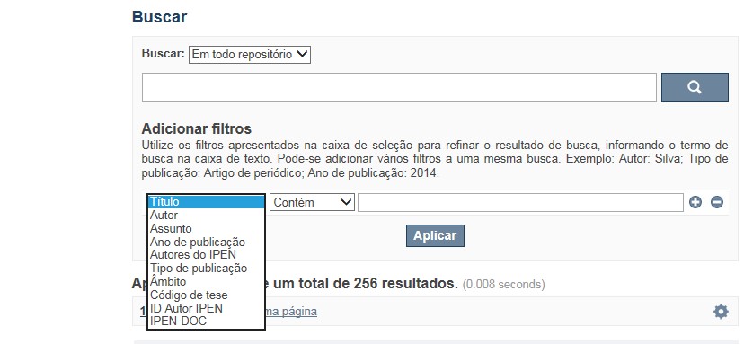
A pesquisa no RD utiliza os recursos de busca da maioria das bases de dados. No entanto algumas dicas podem auxiliar para obter um resultado mais pertinente.
✔ É possível efetuar a busca de um autor ou um termo em todo o RD, por meio do Buscar no Repositório , isto é, o termo solicitado será localizado em qualquer campo do RD. No entanto esse tipo de pesquisa não é recomendada a não ser que se deseje um resultado amplo e generalizado.
✔ A pesquisa apresentará melhor resultado selecionando um dos filtros disponíveis em Navegar
✔ Os filtros disponíveis em Navegar tais como: Coleções, Ano de publicação, Títulos, Assuntos, Autores, Revista, Tipo de publicação são autoexplicativos. O filtro, Autores IPEN apresenta uma relação com os autores vinculados ao IPEN; o ID Autor IPEN diz respeito ao número único de identificação de cada autor constante no RD e sob o qual estão agrupados todos os seus trabalhos independente das variáveis do seu nome; Tipo de acesso diz respeito à acessibilidade do documento, isto é , sujeito as leis de direitos autorais, ID RT apresenta a relação dos relatórios técnicos, restritos para consulta das comunidades indicadas.
A opção Busca avançada utiliza os conectores da lógica boleana, é o melhor recurso para combinar chaves de busca e obter documentos relevantes à sua pesquisa, utilize os filtros apresentados na caixa de seleção para refinar o resultado de busca. Pode-se adicionar vários filtros a uma mesma busca.
Exemplo:
Buscar os artigos apresentados em um evento internacional de 2015, sobre loss of coolant, do autor Maprelian.
Autor: Maprelian
Título: loss of coolant
Tipo de publicação: Texto completo de evento
Ano de publicação: 2015
✔ Para indexação dos documentos é utilizado o Thesaurus do INIS, especializado na área nuclear e utilizado em todos os países membros da International Atomic Energy Agency – IAEA , por esse motivo, utilize os termos de busca de assunto em inglês; isto não exclui a busca livre por palavras, apenas o resultado pode não ser tão relevante ou pertinente.
✔ 95% do RD apresenta o texto completo do documento com livre acesso, para aqueles que apresentam o ![]() significa que e o documento está sujeito as leis de direitos autorais, solicita-se nesses casos contatar a Biblioteca do IPEN,
bibl@ipen.br
.
significa que e o documento está sujeito as leis de direitos autorais, solicita-se nesses casos contatar a Biblioteca do IPEN,
bibl@ipen.br
.
✔ Ao efetuar a busca por um autor o RD apresentará uma relação de todos os trabalhos depositados no RD. No lado direito da tela são apresentados os coautores com o número de trabalhos produzidos em conjunto bem como os assuntos abordados e os respectivos anos de publicação agrupados.
✔ O RD disponibiliza um quadro estatístico de produtividade, onde é possível visualizar o número dos trabalhos agrupados por tipo de coleção, a medida que estão sendo depositados no RD.
✔ Na página inicial nas referências são sinalizados todos os autores IPEN, ao clicar nesse símbolo ![]() será aberta uma nova página correspondente à aquele autor – trata-se da página do pesquisador.
será aberta uma nova página correspondente à aquele autor – trata-se da página do pesquisador.
✔ Na página do pesquisador, é possível verificar, as variações do nome, a relação de todos os trabalhos com texto completo bem como um quadro resumo numérico; há links para o Currículo Lattes e o Google Acadêmico ( quando esse for informado).
ATENÇÃO!
ESTE TEXTO "AJUDA" ESTÁ SUJEITO A ATUALIZAÇÕES CONSTANTES, A MEDIDA QUE NOVAS FUNCIONALIDADES E RECURSOS DE BUSCA FOREM SENDO DESENVOLVIDOS PELAS EQUIPES DA BIBLIOTECA E DA INFORMÁTICA.
O gerenciamento do Repositório está a cargo da Biblioteca do IPEN. Constam neste RI, até o presente momento 20.950 itens que tanto podem ser artigos de periódicos ou de eventos nacionais e internacionais, dissertações e teses, livros, capítulo de livros e relatórios técnicos. Para participar do RI-IPEN é necessário que pelo menos um dos autores tenha vínculo acadêmico ou funcional com o Instituto. Nesta primeira etapa de funcionamento do RI, a coleta das publicações é realizada periodicamente pela equipe da Biblioteca do IPEN, extraindo os dados das bases internacionais tais como a Web of Science, Scopus, INIS, SciElo além de verificar o Currículo Lattes. O RI-IPEN apresenta também um aspecto inovador no seu funcionamento. Por meio de metadados específicos ele está vinculado ao sistema de gerenciamento das atividades do Plano Diretor anual do IPEN (SIGEPI). Com o objetivo de fornecer dados numéricos para a elaboração dos indicadores da Produção Cientifica Institucional, disponibiliza uma tabela estatística registrando em tempo real a inserção de novos itens. Foi criado um metadado que contém um número único para cada integrante da comunidade científica do IPEN. Esse metadado se transformou em um filtro que ao ser acionado apresenta todos os trabalhos de um determinado autor independente das variáveis na forma de citação do seu nome.
A elaboração do projeto do RI do IPEN foi iniciado em novembro de 2013, colocado em operação interna em julho de 2014 e disponibilizado na Internet em junho de 2015. Utiliza o software livre Dspace, desenvolvido pelo Massachusetts Institute of Technology (MIT). Para descrição dos metadados adota o padrão Dublin Core. É compatível com o Protocolo de Arquivos Abertos (OAI) permitindo interoperabilidade com repositórios de âmbito nacional e internacional.
1. Portaria IPEN-CNEN/SP nº 387, que estabeleceu os princípios que nortearam a criação do RDI, clique aqui.
2. A experiência do Instituto de Pesquisas Energéticas e Nucleares (IPEN-CNEN/SP) na criação de um Repositório Digital Institucional – RDI, clique aqui.
O Repositório Digital do IPEN é um equipamento institucional de acesso aberto, criado com o objetivo de reunir, preservar, disponibilizar e conferir maior visibilidade à Produção Científica publicada pelo Instituto, desde sua criação em 1956.
Operando, inicialmente como uma base de dados referencial o Repositório foi disponibilizado na atual plataforma, em junho de 2015. No Repositório está disponível o acesso ao conteúdo digital de artigos de periódicos, eventos, nacionais e internacionais, livros, capítulos, dissertações, teses e relatórios técnicos.
A elaboração do projeto do RI do IPEN foi iniciado em novembro de 2013, colocado em operação interna em julho de 2014 e disponibilizado na Internet em junho de 2015. Utiliza o software livre Dspace, desenvolvido pelo Massachusetts Institute of Technology (MIT). Para descrição dos metadados adota o padrão Dublin Core. É compatível com o Protocolo de Arquivos Abertos (OAI) permitindo interoperabilidade com repositórios de âmbito nacional e internacional.
O gerenciamento do Repositório está a cargo da Biblioteca do IPEN. Constam neste RI, até o presente momento 20.950 itens que tanto podem ser artigos de periódicos ou de eventos nacionais e internacionais, dissertações e teses, livros, capítulo de livros e relatórios técnicos. Para participar do RI-IPEN é necessário que pelo menos um dos autores tenha vínculo acadêmico ou funcional com o Instituto. Nesta primeira etapa de funcionamento do RI, a coleta das publicações é realizada periodicamente pela equipe da Biblioteca do IPEN, extraindo os dados das bases internacionais tais como a Web of Science, Scopus, INIS, SciElo além de verificar o Currículo Lattes. O RI-IPEN apresenta também um aspecto inovador no seu funcionamento. Por meio de metadados específicos ele está vinculado ao sistema de gerenciamento das atividades do Plano Diretor anual do IPEN (SIGEPI). Com o objetivo de fornecer dados numéricos para a elaboração dos indicadores da Produção Cientifica Institucional, disponibiliza uma tabela estatística registrando em tempo real a inserção de novos itens. Foi criado um metadado que contém um número único para cada integrante da comunidade científica do IPEN. Esse metadado se transformou em um filtro que ao ser acionado apresenta todos os trabalhos de um determinado autor independente das variáveis na forma de citação do seu nome.