Navegação Periódicos - Artigos por assunto "satellites"
- Página inicial
- →
- IPEN
- →
- Periódicos - Artigos
- →
- Navegação Periódicos - Artigos por assunto
- Sobre
- Perfil Técnico
- Política de funcionamento
- Ajuda
- Apresentação
Navegação Periódicos - Artigos por assunto "satellites"
Itens para a visualização no momento 1-17 de 17
-
OLIVEIRA, ALINE M. de; SOUZA, CRISTINA T.; OLIVEIRA, NARA P.M. de; MELO, ALINE K.S.; LOPES, FABIO J.S.
 ; LANDULFO, EDUARDO
; ELBERN, HENDRIK; HOELZEMANN, JUDITH J.. Analysis of atmospheric aerosol optical properties in the northeast Brazilian atmosphere with remote sensing data from MODIS and CALIOP/CALIPSO satellites, AERONET photometers and a ground-based Lidar.
Atmosphere,
v. 10,
n. 10,
p. 1-22,
2019.
DOI:
10.3390/atmos10100594
Abstract:
A 12-year analysis, from 2005 to 2016, of atmospheric aerosol optical properties focusing
for the first time on Northeast Brazil (NEB) was performed based on four di erent remote sensing
datasets: the Moderate Resolution Imaging Spectroradiometer (MODIS), the Aerosol Robotic Network
(AERONET), the Cloud-Aerosol LIDAR with Orthogonal Polarization (CALIOP) and a ground-based
Lidar from Natal. We evaluated and identified distinct aerosol types, considering Aerosol Optical
Depth (AOD) and Angström Exponent (AE). All analyses show that over the NEB, a low aerosol
scenario prevails, while there are two distinct seasons of more elevated AOD that occur every year,
from August to October and January to March. According to MODIS, AOD values ranges from 0.04 to
0.52 over the region with a mean of 0.20 and occasionally isolated outliers of up to 1.21. Aerosol types
were identified as sea spray, biomass burning, and dust aerosols mostly transported from tropical
Africa. Three case studies on days with elevated AOD were performed. All cases identified the
same aerosol types and modeled HYSPLIT backward trajectories confirmed their source-dependent
origins. This analysis is motivated by the implementation of an atmospheric chemistry model with an
advanced data assimilation system that will use the observational database over NEB with the model
to overcome high uncertainties in the model results induced by still unvalidated emission inventories.
; LANDULFO, EDUARDO
; ELBERN, HENDRIK; HOELZEMANN, JUDITH J.. Analysis of atmospheric aerosol optical properties in the northeast Brazilian atmosphere with remote sensing data from MODIS and CALIOP/CALIPSO satellites, AERONET photometers and a ground-based Lidar.
Atmosphere,
v. 10,
n. 10,
p. 1-22,
2019.
DOI:
10.3390/atmos10100594
Abstract:
A 12-year analysis, from 2005 to 2016, of atmospheric aerosol optical properties focusing
for the first time on Northeast Brazil (NEB) was performed based on four di erent remote sensing
datasets: the Moderate Resolution Imaging Spectroradiometer (MODIS), the Aerosol Robotic Network
(AERONET), the Cloud-Aerosol LIDAR with Orthogonal Polarization (CALIOP) and a ground-based
Lidar from Natal. We evaluated and identified distinct aerosol types, considering Aerosol Optical
Depth (AOD) and Angström Exponent (AE). All analyses show that over the NEB, a low aerosol
scenario prevails, while there are two distinct seasons of more elevated AOD that occur every year,
from August to October and January to March. According to MODIS, AOD values ranges from 0.04 to
0.52 over the region with a mean of 0.20 and occasionally isolated outliers of up to 1.21. Aerosol types
were identified as sea spray, biomass burning, and dust aerosols mostly transported from tropical
Africa. Three case studies on days with elevated AOD were performed. All cases identified the
same aerosol types and modeled HYSPLIT backward trajectories confirmed their source-dependent
origins. This analysis is motivated by the implementation of an atmospheric chemistry model with an
advanced data assimilation system that will use the observational database over NEB with the model
to overcome high uncertainties in the model results induced by still unvalidated emission inventories.
Palavras-Chave: aerosols; aerosol monitoring; optical radar; dusts; datasets; satellites; atmospherics; meteorology; optical properties; brazil; atmospheric circulation
. Analysis of atmospheric aerosol optical properties in the northeast Brazilian atmosphere with remote sensing data from MODIS and CALIOP/CALIPSO satellites, AERONET photometers and a ground-based Lidar. Atmosphere, v. 10, n. 10, p. 1-22, 2019. DOI: 10.3390/atmos10100594. Disponível em: http://repositorio.ipen.br/handle/123456789/30378. Acesso em: $DATA.Como referenciar este itemEsta referência é gerada automaticamente de acordo com as normas do estilo IPEN/SP (ABNT NBR 6023) e recomenda-se uma verificação final e ajustes caso necessário.

-
LOPES, F.J.S.; LANDULFO, E.
; VAUGHAN, M.A.. Assessment of the CALIPSO lidar 532 nm version 3 lidas ratio models using a ground-based lidar and AERONET sun photometers in Brazil.
Atmospheric Measurement Techniques Discussions,
v. 6,
p. 1143-1199,
2013.
Palavras-Chave: brazil; optical radar; satellites; remote sensing; sun; photometers; aerosol monitoring; climates
. Assessment of the CALIPSO lidar 532 nm version 3 lidas ratio models using a ground-based lidar and AERONET sun photometers in Brazil. Atmospheric Measurement Techniques Discussions, v. 6, p. 1143-1199, 2013. Disponível em: http://repositorio.ipen.br/handle/123456789/8482. Acesso em: $DATA.Como referenciar este itemEsta referência é gerada automaticamente de acordo com as normas do estilo IPEN/SP (ABNT NBR 6023) e recomenda-se uma verificação final e ajustes caso necessário.
-
WEBB, ALEX J.; BOSCH, HARTMUT; PARKER, ROBERT J.; GATTI, LUCIANA V.
; GLOOR, EMANUEL; PALMER, PAUL I.; BASSO, LUANA S.
; CHIPPERFIELD, MARTIN P.; CORREIA, CAIO S.C.
; DOMINGUES, LUCAS G.
; FENG, LIANG; GONZI, SIEGFRIED; MILLER, JOHN B.; WARNEKE, THORSTEN; WILSON, CHRISTOPHER. CHsub(4) concentrations over the Amazon from GOSAT consistent with in situ vertical profile data.
Journal of Geophysical Research: Atmospheres,
v. 121,
n. 18,
p. 11,006-11,020,
2016.
Abstract:
The Amazon Basin contains large wetland ecosystems which are important
sources of methane (CH4). Space-borne observations of atmospheric CH4
provide constraints on emissions from these remote ecosystems, but lack of
validation precludes robust estimates. We present the rst validation of CH4
columns in the Amazon from the Greenhouse gases Observing SATellite (GOSAT)
using dedicated vertical pro le measurements of CH4 over ve sites across
the Amazon Basin. These aircraft pro les, combined with the TOMCAT stratospheric
model, are vertically integrated allowing direct comparison to the GOSAT
measurements. The absolute columns agree within uncertainties or show no
signi cant di erence at three of the aircraft sites (-1.9 2.2 ppb and 3.6 4.3
ppb at one site with two di erent campaigns; and 3.6 1.7 ppb, and 6.6 2.6
ppb at the other two), whilst at two sites GOSAT XCH4 is shown to be slightly
higher than aircraft measurements, by up to approximately 10 ppb in the
most di ering case (8.1 2.1 ppb and 9.7 2.8 ppb). The seasonality in XCH4
seen by the aircraft pro les is also well captured. GOSAT observes elevated
concentrations in the north-west corner of South America in the dry season
and enhanced concentrations elsewhere in the Amazon Basin in the wet season;
with the strongest seasonal di erences coinciding with regions in Bolivia
known to contain large wetlands. Our results are encouraging evidence
that these GOSAT CH4 columns are in good agreement with in situ measurements
and can be reliably used to provide new insights into tropical methane
emissions
Palavras-Chave: methane; validation; greenhouse gases; satellites; south america; comparative evaluations
. CHsub(4) concentrations over the Amazon from GOSAT consistent with in situ vertical profile data. Journal of Geophysical Research: Atmospheres, v. 121, n. 18, p. 11,006-11,020, 2016. Disponível em: http://repositorio.ipen.br/handle/123456789/26760. Acesso em: $DATA.Como referenciar este itemEsta referência é gerada automaticamente de acordo com as normas do estilo IPEN/SP (ABNT NBR 6023) e recomenda-se uma verificação final e ajustes caso necessário.
-
FENG, LIANG; PALMER, PAUL I.; BÖSCH, HARTMUT; PARKER, ROBERT J.; WEBB, ALEX J.; CORREIA, CAIO S.C.
; DEUTSCHER, NICHOLAS M.; DOMINGUES, LUCAS G.
; FEIST, DIETRICH G.; GATTI, LUCIANA V.
; GLOOR, EMANUEL; HASE, FRANK; KIVI, RIGEL; LIU, YI; MILLER, JOHN B.; MORINO, ISAMU; SUSSMANN, RALF; STRONG, KIMBERLY; UCHINO, OSAMU; WANG, JING; ZAHN, ANDREAS. Consistent regional fluxes of CHsub(4) and COsub(2) inferred from GOSAT proxy XCHsub(4)XCOsub(2) retrievals, 2010-2014.
Atmospheric Chemistry and Physics,
v. 17,
n. 7,
p. 4781-4797,
2017.
DOI:
10.5194/acp-17-4781-2017
Abstract:
We use the GEOS-Chem global 3-D model of atmospheric chemistry and transport and an ensemble Kalman filter to simultaneously infer regional fluxes of methane (CH4) and carbon dioxide (CO2) directly from GOSAT retrievals of XCH4:XCO2, using sparse ground-based CH4 and CO2 mole fraction data to anchor the ratio. This work builds on previously reported theory that takes advantage that: 1) these ratios are less prone to systematic error than either the full physics data products or the proxy CH4 data products; and 2) the resulting CH4 and CO2 fluxes are self-consistent. We show that a
posteriori fluxes inferred from the GOSAT data generally outperform the fluxes inferred only from in situ data, as expected. GOSAT CH4 and CO2 fluxes are consistent with global growth rates for CO2 and CH4 reported by NOAA, and with a range of independent data including in particular new profile measurements (0-7 km) over the Amazon basin that were collected specifically to help validate GOSAT over this geographical region. We find that large-scale multi-year annual a posteriori CO2 fluxes inferred from GOSAT data are similar to those inferred from the in situ surface data but with smaller uncertainties, particularly over the tropics. GOSAT data are consistent with smaller peak-topeak
seasonal amplitudes of CO2 than either a priori or the in situ inversion, particularly over the tropics and the southern extra-tropics. Over the northern extra-tropics, GOSAT data show larger uptake than the a priori but less than the in situ inversion, resulting in small net emissions over the year. We also find evidence that the carbon balance of tropical South America was perturbed
following the droughts of 2010 and 2012 with net annual fluxes not returning to an approximate annual balance until 2013. In contrast, GOSAT data significantly changed the a priori spatial distribution of CH4 emission with a 40% increase over tropical South America and tropical Asia and smaller decrease over Eurasia and temperate South America. We find no evidence from GOSAT that tropical South American CH4 fluxes were dramatically affected by the two large-scale Amazon droughts. However, we find that GOSAT data are consistent with double seasonal peaks in fluxes that are reproduced over the five years we studied: a small peak in January to April and a larger peak
60 in June to October, which is likely due to superimposed emissions from different geographical regions.
Palavras-Chave: methane; carbon dioxide; satellites; south america; brazil; simulation
. Consistent regional fluxes of CHsub(4) and COsub(2) inferred from GOSAT proxy XCHsub(4)XCOsub(2) retrievals, 2010-2014. Atmospheric Chemistry and Physics, v. 17, n. 7, p. 4781-4797, 2017. DOI: 10.5194/acp-17-4781-2017. Disponível em: http://repositorio.ipen.br/handle/123456789/26757. Acesso em: $DATA.Como referenciar este itemEsta referência é gerada automaticamente de acordo com as normas do estilo IPEN/SP (ABNT NBR 6023) e recomenda-se uma verificação final e ajustes caso necessário.
-
LOPES, F.J.S.; LANDULFO, E.
; VAUGHAN, M.A.. Evaluating CALIPSO's 532 nm lidar ratio selection algorithm using AERONET sun photometers in Brazil.
Atmospheric Measurement Techniques,
v. 6,
p. 3281-3299,
2013.
Palavras-Chave: brazil; optical radar; satellites; clouds; aerosols; algorithms; sun; photometers; validation
. Evaluating CALIPSO's 532 nm lidar ratio selection algorithm using AERONET sun photometers in Brazil. Atmospheric Measurement Techniques, v. 6, p. 3281-3299, 2013. Disponível em: http://repositorio.ipen.br/handle/123456789/8483. Acesso em: $DATA.Como referenciar este itemEsta referência é gerada automaticamente de acordo com as normas do estilo IPEN/SP (ABNT NBR 6023) e recomenda-se uma verificação final e ajustes caso necessário.
-
PALACIOS, RAFAEL; NASSARDEN, DANIELLE C.S.; FRANCO, MARCO A.; MORAIS, FERNANDO G.
; MACHADO, LUIZ A.T.; RIZZO, LUCIANA V.; CIRINO, GLAUBER; PEREIRA, AUGUSTO G.C.; RIBEIRO, PRISCILA dos S.; BARROS, LUCAS R.C.; BIUDES, MARCELO S.; CURADO, LEONE F.A.; RODRIGUES, THIAGO R.; MENEZES, JORGE; LANDULFO, EDUARDO
; ARTAXO, PAULO. Evaluation of MODIS Dark Target AOD product with 3 and 10 km resolution in Amazonia.
Atmosphere,
v. 13,
n. 11,
p. 1-16,
2022.
DOI:
10.3390/atmos13111742
Abstract:
The techniques and analyses employed by remote sensing provide key information about atmospheric particle properties at regional and global scales. However, limitations in optical spectral models used to represent the different types of aerosols in the atmosphere and their effects (direct and indirect) are still one of the major causes of sources of uncertainties and substantial impacts in climate prediction. There are no studies yet in South America, especially in the Amazon Basin, that have evaluated the advantages, disadvantages, inconsistencies, applicability, and suitability of the MODIS sensor (Moderate Resolution Imaging Spectroradiometer) destined for monitoring the ambient aerosol optical thickness over rivers and continents. In this study, the results of the DT (Dark Target) algorithm for products with 3 km and 10 km resolutions were systematically evaluated for six sites in the Amazon rainforest. The comparisons between the products were carried out with the AERONET (Aerosol Robotic Network) measurements, which were used as reference. Statistical parameters between AERONET vs. MODIS were also evaluated based on biomass burning records in the site regions. Here, the DT 10 km product showed satisfactory performance for the Amazon region, with observations between the expected error (EE) limits above 66%, in addition to R > 0.8 and RMSE < 0.3. However, the regional analysis for the two sites in the central and southern regions of the Amazon basin did not have the same performance, where the results showed an EE of 24 and 47%, respectively. The DT 3 km product did not perform well in any site, with an EE below 50%. Both products overestimated the AOD, but the 3 km product overestimated it approximately four times more due to its algorithm setup. Thus, we recommend the 10 km product for general analysis in Amazonia. Regional biomass burning records showed a direct relationship with the AERONET vs. MODIS DT with overestimation of both products. All variations between products and sites were justified based on the difficulty of retrieving surface reflectance and the model selected for local aerosols. Improvements in the optical spectral model currently implemented in the algorithms, with more realistic representations of the main types of the aerosol present in the Amazon Basin, may contribute to better performance among the evaluated products.
Palavras-Chave: aerosol monitoring; remote sensing; satellites; sensors; amazon river
. Evaluation of MODIS Dark Target AOD product with 3 and 10 km resolution in Amazonia. Atmosphere, v. 13, n. 11, p. 1-16, 2022. DOI: 10.3390/atmos13111742. Disponível em: http://repositorio.ipen.br/handle/123456789/33367. Acesso em: $DATA.Como referenciar este itemEsta referência é gerada automaticamente de acordo com as normas do estilo IPEN/SP (ABNT NBR 6023) e recomenda-se uma verificação final e ajustes caso necessário.
-
SILVA, JONATAN da
; MORAIS, FERNANDO G.
; FRANCO, MARCO A.; LOPES, FABIO J.S.
; ARRUDA, GREGORI de A.
; YOSHIDA, ALEXANDRE C.
; CORREIA, ALEXANDRE; LANDULFO, EDUARDO
. Exploring the twilight zone: a multi-sensor approach.
EPJ Web of Conferences,
v. 237,
p. 1-4,
2020.
DOI:
10.1051/epjconf/202023707015
Abstract:
This study shows a set of analysis of
measurements from ground-based and satellite
instruments to characterize the twilight zone (TLZ)
between clouds and aerosols in São Paulo, Brazil.
In the vicinity of clouds turbulence measurements
showed an intense upward movement of aerosol
layers, while sunphotometer results showed an
increase in aerosol optical depth, and lidar
measurements showed an increase in the
backscatter vertical profile signal.
Palavras-Chave: atmospheres; clouds; earth atmosphere; aerosols; optical radar; satellites; urban areas; radiations; meteorology
. Exploring the twilight zone: a multi-sensor approach. EPJ Web of Conferences, v. 237, p. 1-4, 2020. DOI: 10.1051/epjconf/202023707015. Disponível em: http://repositorio.ipen.br/handle/123456789/31477. Acesso em: $DATA.Como referenciar este itemEsta referência é gerada automaticamente de acordo com as normas do estilo IPEN/SP (ABNT NBR 6023) e recomenda-se uma verificação final e ajustes caso necessário.
-
LOPES, FABIO J. da S.
; CARVALHO, SILVANIA A.; CATALANI, FERNANDO; SILVA, JONATAN J. da
; ALMEIDA, ROGERIO M. de; RIBEIRO, FABIO de J.; FELLOWS, CARLOS E.; LANDULFO, EDUARDO
; MENEGATTI, CARLOS R.; PEIXOTO, CARLOS J.T.. First lidar campaign in the industrial sites of Volta Redonda-RJ and Lorena-SP, Brazil.
Remote Sensing,
v. 14,
n. 7,
p. 1-21,
2022.
DOI:
10.3390/rs14071675
Abstract:
We report on the first aerosol profiling campaign in the Paraíba valley, a hub connecting
the region between the two largest Brazilian metropolitan areas, São Paulo and Rio de Janeiro. São
Paulo Sanitation Technology Company (CETESB) air quality and Cloud-Aerosol Lidar and Infrared
Pathfinder Satellite Observations (CALIPSO) data show homogeneous behavior of the atmosphere
throughout the region. A more detailed description of the particulate material in the local atmosphere,
including its temporal dependence, can be obtained by using ground-based lidars. Measurements
were carried out with a backscatter lidar system in two industrial cities, Volta Redonda and Lorena.
The aerosol backscatter profiles present several peaks at different altitudes, indicating the presence of
aerosol in several atmospheric layers. In addition, The Hybrid Single Particle Lagrangian Integrated
Trajectory (HYSPLIT) air-mass back-trajectories indicate a possible detection of long-range aerosol
transported from biomass burning areas of South America. The present study emphasizes the
importance of investigating and monitoring the emission of particulate matter at this important hub
connection between two dense populated regions of Brazil.
Palavras-Chave: optical radar; satellites; aerosol monitoring; atmospheres; industrial wastes; pollution
. First lidar campaign in the industrial sites of Volta Redonda-RJ and Lorena-SP, Brazil. Remote Sensing, v. 14, n. 7, p. 1-21, 2022. DOI: 10.3390/rs14071675. Disponível em: http://repositorio.ipen.br/handle/123456789/33210. Acesso em: $DATA.Como referenciar este itemEsta referência é gerada automaticamente de acordo com as normas do estilo IPEN/SP (ABNT NBR 6023) e recomenda-se uma verificação final e ajustes caso necessário.
-
WANG, JAMES S.; KAWA, S.R.; COLLATZ, G.J.; SASAKAWA, MOTOKI; GATTI, LUCIANA V.
; MACHIDA, TOSHINOBU; LIU, YUPING; MANYIN, MICHAEL E.. A global synthesis inversion analysis of recent variability in CO2 fluxes using GOSAT and in situ observations.
Atmospheric Chemistry and Physics,
v. 18,
n. 15,
p. 11097-11124,
2018.
DOI:
10.5194/acp-18-11097-2018
Abstract:
The precise contribution of the two major sinks for
anthropogenic CO2 emissions, terrestrial vegetation and the
ocean, and their location and year-to-year variability are not
well understood. Top-down estimates of the spatiotemporal
variations in emissions and uptake of CO2 are expected to
benefit from the increasing measurement density brought by
recent in situ and remote CO2 observations.We uniquely apply
a batch Bayesian synthesis inversion at relatively high
resolution to in situ surface observations and bias-corrected
GOSAT satellite column CO2 retrievals to deduce the global
distributions of natural CO2 fluxes during 2009–2010. The
GOSAT inversion is generally better constrained than the
in situ inversion, with smaller posterior regional flux uncertainties
and correlations, because of greater spatial coverage,
except over North America and northern and southern
high-latitude oceans. Complementarity of the in situ and
GOSAT data enhances uncertainty reductions in a joint inversion;
however, remaining coverage gaps, including those
associated with spatial and temporal sampling biases in the
passive satellite measurements, still limit the ability to accurately
resolve fluxes down to the sub-continental or subocean
basin scale. The GOSAT inversion produces a shift in
the global CO2 sink from the tropics to the north and south
relative to the prior, and an increased source in the tropics of
2 PgC yr1 relative to the in situ inversion, similar to what
is seen in studies using other inversion approaches. This result
may be driven by sampling and residual retrieval biases
in the GOSAT data, as suggested by significant discrepancies
between posterior CO2 distributions and surface in situ and
HIPPO mission aircraft data. While the shift in the global
sink appears to be a robust feature of the inversions, the partitioning
of the sink between land and ocean in the inversions
using either in situ or GOSAT data is found to be sensitive to
prior uncertainties because of negative correlations in the flux
errors. The GOSAT inversion indicates significantly less CO2
uptake in the summer of 2010 than in 2009 across northern
regions, consistent with the impact of observed severe heat
waves and drought. However, observations from an in situ
network in Siberia imply that the GOSAT inversion exaggerates
the 2010–2009 difference in uptake in that region,
while the prior CASA-GFED model of net ecosystem production
and fire emissions reasonably estimates that quantity.
The prior, in situ posterior, and GOSAT posterior all indicate
greater uptake over North America in spring to early summer
of 2010 than in 2009, consistent with wetter conditions.
The GOSAT inversion does not show the expected impact on
fluxes of a 2010 drought in the Amazon; evaluation of posterior
mole fractions against local aircraft profiles suggests
that time-varying GOSAT coverage can bias the estimation
of interannual flux variability in this region.
Palavras-Chave: satellites; greenhouse gases; carbon dioxide; in-situ processing; satellite atmospheres; controlled atmospheres
. A global synthesis inversion analysis of recent variability in CO2 fluxes using GOSAT and in situ observations. Atmospheric Chemistry and Physics, v. 18, n. 15, p. 11097-11124, 2018. DOI: 10.5194/acp-18-11097-2018. Disponível em: http://repositorio.ipen.br/handle/123456789/29355. Acesso em: $DATA.Como referenciar este itemEsta referência é gerada automaticamente de acordo com as normas do estilo IPEN/SP (ABNT NBR 6023) e recomenda-se uma verificação final e ajustes caso necessário.
-
BERGAMASCHI, PETER; FRANKENBERG, CHRISTIAN; MEIRINK, JAN F.; KROL, MAARTEN; VILANI, GABRIELLA; HOUWELING, SANDER; DENTENER, FRANK; DLUGOKENCKY, EDWARD J.; MILLER, JOHN B.; GATTI, LUCIANA V.
; ENGEL, ANDREAS; LEVIN, INGEBORG. Inverse modeling of global and regional CHsub(4) emissions using SCIAMACHY satellite retrievals.
Journal of Geophysical Research - Atmospheres,
v. 114,
p. D22301-1 - D22301-28,
2009.
Palavras-Chave: methane; greenhouse gases; hydrocarbons; biomass; burnup; gaseous wastes; satellites; remote sensing; atmospheric chemistry; tropical regions; monitoring
. Inverse modeling of global and regional CHsub(4) emissions using SCIAMACHY satellite retrievals. Journal of Geophysical Research - Atmospheres, v. 114, p. D22301-1 - D22301-28, 2009. Disponível em: http://repositorio.ipen.br/handle/123456789/4776. Acesso em: $DATA.Como referenciar este itemEsta referência é gerada automaticamente de acordo com as normas do estilo IPEN/SP (ABNT NBR 6023) e recomenda-se uma verificação final e ajustes caso necessário.
-
PANDEY, SUDHANSHU; HOUWELING, SANDER; KROL, MAARTEN; AHEN, ILSE; CHEVALLIER, FREDERIC; DLUGOKENCKY, EDWARD J.; GATTI, LUCIANA V.
; GLOOR, EMANUEL; MILLER, JOHN B.; DETMERS, ROB; MACHIDA, TOSHINOBU; ROCKMANN, THOMAS. Inverse modeling of GOSAT-retrieved rations of total column CHsub(4) and COsub(2) for 2009 and 2010.
Atmospheric Chemistry and Physics,
v. 16,
n. 8,
p. 5043-5062,
2016.
Palavras-Chave: simulation; methane; carbon dioxide; comparative evaluations; investigations; greenhouse gases; satellites; limiting values
. Inverse modeling of GOSAT-retrieved rations of total column CHsub(4) and COsub(2) for 2009 and 2010. Atmospheric Chemistry and Physics, v. 16, n. 8, p. 5043-5062, 2016. Disponível em: http://repositorio.ipen.br/handle/123456789/26504. Acesso em: $DATA.Como referenciar este itemEsta referência é gerada automaticamente de acordo com as normas do estilo IPEN/SP (ABNT NBR 6023) e recomenda-se uma verificação final e ajustes caso necessário.
-
BENCHERIF, HASSAN; BÈGUE, NELSON; PINHEIRO, DAMARIS K.; DU PREEZ, DAVID J.; CADET, JEAN-MAURICE; LOPES, FABIO J. da S.
; SHIKWAMBANA, LERATO; LANDULFO, EDUARDO
; VESCOVINI, THOMAS; LABUSCHAGNE, CASPER; SILVA, JONATAN J.
; ANABOR, VAGNER; COHEUR, PIERRE-FRANÇOIS; MBATHA, NKANYISO; HADJI-LAZARO, JULIETTE; SIVAKUMAR, VENKATARAMAN; CLERBAUX, CATHY. Investigating the long-range transport of aerosol plumes following the Amazon fires (August 2019): a multi-instrumental approach from ground-based and satellite observations.
Remote Sensing,
v. 12,
n. 22,
p. 1-18,
2020.
DOI:
10.3390/rs12223846
Abstract:
Despite a number of studies on biomass burning (BB) emissions in the atmosphere, observation of the associated aerosols and pollutants requires continuous efforts. Brazil, and more broadly Latin America, is one of the most important seasonal sources of BB, particularly in the Amazon region. Uncertainty about aerosol loading in the source regions is a limiting factor in terms of understanding the role of aerosols in climate modelling. In the present work, we investigated the Amazon BB episode that occurred during August 2019 and made the international headlines, especially when the smoke plumes plunged distant cities such as São Paulo into darkness. Here, we used satellite and ground-based observations at different locations to investigate the long-range transport of aerosol plumes generated by the Amazon fires during the study period. The monitoring of BB activity was carried out using fire related pixel count from the moderate resolution imaging spectroradiometer (MODIS) onboard the Aqua and Terra platforms, while the distribution of carbon monoxide (CO) concentrations and total columns were obtained from the infrared atmospheric sounding interferometer (IASI) onboard the METOP-A and METOP-B satellites. In addition, AERONET sun-photometers as well as the MODIS instrument made aerosol optical depth (AOD) measurements over the study region. Our datasets are consistent with each other and highlight AOD and CO variations and long-range transport of the fire plume from the source regions in the Amazon basin. We used the Lagrangian transport model FLEXPART (FLEXible PARTicle) to simulate backward dispersion, which showed good agreement with satellite and ground measurements observed over the study area. The increase in Rossby wave activity during the 2019 austral winter the Southern Hemisphere may have contributed to increasing the efficiency of large-scale transport of aerosol plumes generated by the Amazon fires during the study period.
Palavras-Chave: biomass; fires; aerosols; aerosol wastes; air transport; carbon monoxide; satellites; plumes; air pollution; amazon river
. Investigating the long-range transport of aerosol plumes following the Amazon fires (August 2019): a multi-instrumental approach from ground-based and satellite observations. Remote Sensing, v. 12, n. 22, p. 1-18, 2020. DOI: 10.3390/rs12223846. Disponível em: http://repositorio.ipen.br/handle/123456789/31815. Acesso em: $DATA.Como referenciar este itemEsta referência é gerada automaticamente de acordo com as normas do estilo IPEN/SP (ABNT NBR 6023) e recomenda-se uma verificação final e ajustes caso necessário.
-
LOPES, FABIO J. da S.; LANDULFO, EDUARDO
. Multi-instrumental study of aerosol optical properties over the city of Sao Paulo: lidar, sunphotometer and CALIPSO satellite.
Optica Pura y Aplicada,
v. 41,
n. 2,
p. 75-81,
2008.
Palavras-Chave: aerosols; clouds; optical properties; optical radar; satellites
. Multi-instrumental study of aerosol optical properties over the city of Sao Paulo: lidar, sunphotometer and CALIPSO satellite. Optica Pura y Aplicada, v. 41, n. 2, p. 75-81, 2008. Disponível em: http://repositorio.ipen.br/handle/123456789/5055. Acesso em: $DATA.Como referenciar este itemEsta referência é gerada automaticamente de acordo com as normas do estilo IPEN/SP (ABNT NBR 6023) e recomenda-se uma verificação final e ajustes caso necessário.
-
SMITH, R.B.
; ROMERO, F.; VICENTE, R.
. Plutonium-238: the fuel crisis.
Brazilian Journal of Radiation Sciences,
v. 9,
n. 1A,
p. 1-11,
2021.
DOI:
10.15392/bjrs.v9i1A.1312
Abstract:
Plutonium-238 is currently still the best fuel to power satellites to be sent to deep space in regions where the solar panels can no longer efficiently receive the sunlight. For 50 years, the National Aeronautics and Space Administration (NASA) has used this radioisotope as a fuel in radioisotope thermoelectric generators (RTGs) installed on satellites such as Pioneer 10 and 11, Voyager 1 and 2, Cassini-Huygens and New Horizons, as well as the various rovers sent to the Moon and to Mars, among others. Plutonium-238 is not a naturally occurring isotope on the planet, it was produced in greater quantity during the Cold War period as a by-product of the production of Plutonium-239 used for nuclear bombs. However, after the shutting down of the Savannah River reactors in 1988 and the ending of the Soviet Union in 1991, the United States stock of Plutonium-238 has been increasingly reduced, which threatens NASA's future space projects. This paper presents a brief bibliographic review about the subject, as well as commentaries on the options available to the United States, from restarting the production of this fuel, to possible alternatives for a new type of fuel or equipment that may supply the spacecrafts.
Palavras-Chave: plutonium 238; fuels; radioisotopes; reactors; nuclear fuels; satellites; plutonium oxides; control rooms; fuel elements
. Plutonium-238: the fuel crisis. Brazilian Journal of Radiation Sciences, v. 9, n. 1A, p. 1-11, 2021. DOI: 10.15392/bjrs.v9i1A.1312. Disponível em: http://repositorio.ipen.br/handle/123456789/32089. Acesso em: $DATA.Como referenciar este itemEsta referência é gerada automaticamente de acordo com as normas do estilo IPEN/SP (ABNT NBR 6023) e recomenda-se uma verificação final e ajustes caso necessário.
-
NAUS, STIJN; DOMINGUES, LUCAS G.
; KROL, MAARTEN; LUIJKX, INGRID T.; GATTI, LUCIANA V.
; MILLER, JOHN B.; GLOOR, EMANUEL; BASU, SOURISH; CORREIA, CAIO
; KOREN, GERBRAND; WORDEN, HELEN M.; FLEMMING, JOHANNES; PETRON, GABRIELLE; PETERS, WOUTER. Sixteen years of MOPITT satellite data strongly constrain Amazon CO fire emissions.
Atmospheric Chemistry and Physics,
v. 22,
n. 22,
p. 14735-14750,
2022.
DOI:
10.5194/acp-22-14735-2022
Abstract:
Despite the consensus on the overall downward trend in Amazon forest loss in the previous decade,
estimates of yearly carbon emissions from deforestation still vary widely. Estimated carbon emissions are currently
often based on data from local logging activity reports, changes in remotely sensed biomass, and remote
detection of fire hotspots and burned area. Here, we use 16 years of satellite-derived carbon monoxide (CO)
columns to constrain fire CO emissions from the Amazon Basin between 2003 and 2018. Through data assimilation,
we produce 3 d average maps of fire CO emissions over the Amazon, which we verified to be consistent
with a long-term monitoring programme of aircraft CO profiles over five sites in the Amazon. Our new product
independently confirms a long-term decrease of 54% in deforestation-related CO emissions over the study period.
Interannual variability is large, with known anomalously dry years showing a more than 4-fold increase in
basin-wide fire emissions relative to wet years. At the level of individual Brazilian states, we find that both soil
moisture anomalies and human ignitions determine fire activity, suggesting that future carbon release from fires
depends on drought intensity as much as on continued forest protection. Our study shows that the atmospheric
composition perspective on deforestation is a valuable additional monitoring instrument that complements existing
bottom-up and remote sensing methods for land-use change. Extension of such a perspective to an operational
framework is timely considering the observed increased fire intensity in the Amazon Basin between 2019 and
2021.
Palavras-Chave: carbon; emission; satellites; fires; satellite atmospheres; carbon monoxide; forests; amazon river
. Sixteen years of MOPITT satellite data strongly constrain Amazon CO fire emissions. Atmospheric Chemistry and Physics, v. 22, n. 22, p. 14735-14750, 2022. DOI: 10.5194/acp-22-14735-2022. Disponível em: http://repositorio.ipen.br/handle/123456789/33860. Acesso em: $DATA.Como referenciar este itemEsta referência é gerada automaticamente de acordo com as normas do estilo IPEN/SP (ABNT NBR 6023) e recomenda-se uma verificação final e ajustes caso necessário.
-
LANDULFO, E.
; PAPAYANNIS, A.; ARTAXO, P.; CASTANHO, A.D.A.; FREITAS, A.Z. de
; SOUZA, R.F.; VIEIRA JUNIOR, N.D.
; JORGE, M.P.M.P.; SANCHEZ-CCOYLLO, O.R.; MOREIRA, D.S.. Synergetic measurements of aerosols over Sao Paulo, Brazil using LIDAR, sunphotometer and satellite data during the dry season.
Atmospheric Chemistry and Physics,
v. 3,
p. 1523-1539,
2003.
Palavras-Chave: brazil; optical radar; backscattering; aerosols; sun; photometers; satellites; weather; air pollution
. Synergetic measurements of aerosols over Sao Paulo, Brazil using LIDAR, sunphotometer and satellite data during the dry season. Atmospheric Chemistry and Physics, v. 3, p. 1523-1539, 2003. Disponível em: http://repositorio.ipen.br/handle/123456789/7989. Acesso em: $DATA.Como referenciar este itemEsta referência é gerada automaticamente de acordo com as normas do estilo IPEN/SP (ABNT NBR 6023) e recomenda-se uma verificação final e ajustes caso necessário.
-
DEETER, M.N.; MARTINEZ-ALONSO, S.; GATTI, L.V.
; GLOOR, M.; MILLER, J.B.; DOMINGUES, L.G.
; CORREIA, C.S.C.
. Validation and analysis of MOPITT CO observations of the Amazon Basin.
Atmospheric Measurement Techniques,
v. 9,
n. 8,
p. 3999-4012,
2016.
DOI:
10.5194/amt-9-3999-2016
Abstract:
We analyze satellite retrievals of carbon monoxide
from the MOPITT (Measurements of Pollution in the Troposphere)
instrument over the Amazon Basin, focusing on
the MOPITT Version 6 “multispectral” retrieval product (exploiting
both thermal-infrared and near-infrared channels).
Validation results based on in situ vertical profiles measured
between 2010 and 2013 are presented for four sites in the
Amazon Basin. Results indicate a significant negative bias in
retrieved lower-tropospheric CO concentrations. The possible
influence of smoke aerosol as a source of retrieval bias
is investigated using collocated Aerosol Robotic Network
(AERONET) aerosol optical depth (AOD) measurements at
two sites but does not appear to be significant. Finally, we
exploit the MOPITT record to analyze both the mean annual
cycle and the interannual variability of CO over the Amazon
Basin since 2002.
Palavras-Chave: validation; carbon monoxide; brazil; satellites; pollution; troposphere; measuring instruments
. Validation and analysis of MOPITT CO observations of the Amazon Basin. Atmospheric Measurement Techniques, v. 9, n. 8, p. 3999-4012, 2016. DOI: 10.5194/amt-9-3999-2016. Disponível em: http://repositorio.ipen.br/handle/123456789/26809. Acesso em: $DATA.Como referenciar este itemEsta referência é gerada automaticamente de acordo com as normas do estilo IPEN/SP (ABNT NBR 6023) e recomenda-se uma verificação final e ajustes caso necessário.
Itens para a visualização no momento 1-17 de 17
Buscar no repositório
Navegar
Minha conta
Visualizar
A pesquisa no RD utiliza os recursos de busca da maioria das bases de dados. No entanto algumas dicas podem auxiliar para obter um resultado mais pertinente.
✔ É possível efetuar a busca de um autor ou um termo em todo o RD, por meio do Buscar no Repositório , isto é, o termo solicitado será localizado em qualquer campo do RD. No entanto esse tipo de pesquisa não é recomendada a não ser que se deseje um resultado amplo e generalizado.
✔ A pesquisa apresentará melhor resultado selecionando um dos filtros disponíveis em Navegar
✔ Os filtros disponíveis em Navegar tais como: Coleções, Ano de publicação, Títulos, Assuntos, Autores, Revista, Tipo de publicação são autoexplicativos. O filtro, Autores IPEN apresenta uma relação com os autores vinculados ao IPEN; o ID Autor IPEN diz respeito ao número único de identificação de cada autor constante no RD e sob o qual estão agrupados todos os seus trabalhos independente das variáveis do seu nome; Tipo de acesso diz respeito à acessibilidade do documento, isto é , sujeito as leis de direitos autorais, ID RT apresenta a relação dos relatórios técnicos, restritos para consulta das comunidades indicadas.
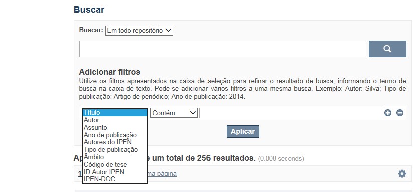
A opção Busca avançada utiliza os conectores da lógica boleana, é o melhor recurso para combinar chaves de busca e obter documentos relevantes à sua pesquisa, utilize os filtros apresentados na caixa de seleção para refinar o resultado de busca. Pode-se adicionar vários filtros a uma mesma busca.
Exemplo:
Buscar os artigos apresentados em um evento internacional de 2015, sobre loss of coolant, do autor Maprelian.
Autor: Maprelian
Título: loss of coolant
Tipo de publicação: Texto completo de evento
Ano de publicação: 2015
✔ Para indexação dos documentos é utilizado o Thesaurus do INIS, especializado na área nuclear e utilizado em todos os países membros da International Atomic Energy Agency – IAEA , por esse motivo, utilize os termos de busca de assunto em inglês; isto não exclui a busca livre por palavras, apenas o resultado pode não ser tão relevante ou pertinente.
✔ 95% do RD apresenta o texto completo do documento com livre acesso, para aqueles que apresentam o ![]() significa que e o documento está sujeito as leis de direitos autorais, solicita-se nesses casos contatar a Biblioteca do IPEN,
bibl@ipen.br
.
significa que e o documento está sujeito as leis de direitos autorais, solicita-se nesses casos contatar a Biblioteca do IPEN,
bibl@ipen.br
.
✔ Ao efetuar a busca por um autor o RD apresentará uma relação de todos os trabalhos depositados no RD. No lado direito da tela são apresentados os coautores com o número de trabalhos produzidos em conjunto bem como os assuntos abordados e os respectivos anos de publicação agrupados.
✔ O RD disponibiliza um quadro estatístico de produtividade, onde é possível visualizar o número dos trabalhos agrupados por tipo de coleção, a medida que estão sendo depositados no RD.
✔ Na página inicial nas referências são sinalizados todos os autores IPEN, ao clicar nesse símbolo ![]() será aberta uma nova página correspondente à aquele autor – trata-se da página do pesquisador.
será aberta uma nova página correspondente à aquele autor – trata-se da página do pesquisador.
✔ Na página do pesquisador, é possível verificar, as variações do nome, a relação de todos os trabalhos com texto completo bem como um quadro resumo numérico; há links para o Currículo Lattes e o Google Acadêmico ( quando esse for informado).
ATENÇÃO!
ESTE TEXTO "AJUDA" ESTÁ SUJEITO A ATUALIZAÇÕES CONSTANTES, A MEDIDA QUE NOVAS FUNCIONALIDADES E RECURSOS DE BUSCA FOREM SENDO DESENVOLVIDOS PELAS EQUIPES DA BIBLIOTECA E DA INFORMÁTICA.
O gerenciamento do Repositório está a cargo da Biblioteca do IPEN. Constam neste RI, até o presente momento 20.950 itens que tanto podem ser artigos de periódicos ou de eventos nacionais e internacionais, dissertações e teses, livros, capítulo de livros e relatórios técnicos. Para participar do RI-IPEN é necessário que pelo menos um dos autores tenha vínculo acadêmico ou funcional com o Instituto. Nesta primeira etapa de funcionamento do RI, a coleta das publicações é realizada periodicamente pela equipe da Biblioteca do IPEN, extraindo os dados das bases internacionais tais como a Web of Science, Scopus, INIS, SciElo além de verificar o Currículo Lattes. O RI-IPEN apresenta também um aspecto inovador no seu funcionamento. Por meio de metadados específicos ele está vinculado ao sistema de gerenciamento das atividades do Plano Diretor anual do IPEN (SIGEPI). Com o objetivo de fornecer dados numéricos para a elaboração dos indicadores da Produção Cientifica Institucional, disponibiliza uma tabela estatística registrando em tempo real a inserção de novos itens. Foi criado um metadado que contém um número único para cada integrante da comunidade científica do IPEN. Esse metadado se transformou em um filtro que ao ser acionado apresenta todos os trabalhos de um determinado autor independente das variáveis na forma de citação do seu nome.
A elaboração do projeto do RI do IPEN foi iniciado em novembro de 2013, colocado em operação interna em julho de 2014 e disponibilizado na Internet em junho de 2015. Utiliza o software livre Dspace, desenvolvido pelo Massachusetts Institute of Technology (MIT). Para descrição dos metadados adota o padrão Dublin Core. É compatível com o Protocolo de Arquivos Abertos (OAI) permitindo interoperabilidade com repositórios de âmbito nacional e internacional.
1. Portaria IPEN-CNEN/SP nº 387, que estabeleceu os princípios que nortearam a criação do RDI, clique aqui.
2. A experiência do Instituto de Pesquisas Energéticas e Nucleares (IPEN-CNEN/SP) na criação de um Repositório Digital Institucional – RDI, clique aqui.
O Repositório Digital do IPEN é um equipamento institucional de acesso aberto, criado com o objetivo de reunir, preservar, disponibilizar e conferir maior visibilidade à Produção Científica publicada pelo Instituto, desde sua criação em 1956.
Operando, inicialmente como uma base de dados referencial o Repositório foi disponibilizado na atual plataforma, em junho de 2015. No Repositório está disponível o acesso ao conteúdo digital de artigos de periódicos, eventos, nacionais e internacionais, livros, capítulos, dissertações, teses e relatórios técnicos.
A elaboração do projeto do RI do IPEN foi iniciado em novembro de 2013, colocado em operação interna em julho de 2014 e disponibilizado na Internet em junho de 2015. Utiliza o software livre Dspace, desenvolvido pelo Massachusetts Institute of Technology (MIT). Para descrição dos metadados adota o padrão Dublin Core. É compatível com o Protocolo de Arquivos Abertos (OAI) permitindo interoperabilidade com repositórios de âmbito nacional e internacional.
O gerenciamento do Repositório está a cargo da Biblioteca do IPEN. Constam neste RI, até o presente momento 20.950 itens que tanto podem ser artigos de periódicos ou de eventos nacionais e internacionais, dissertações e teses, livros, capítulo de livros e relatórios técnicos. Para participar do RI-IPEN é necessário que pelo menos um dos autores tenha vínculo acadêmico ou funcional com o Instituto. Nesta primeira etapa de funcionamento do RI, a coleta das publicações é realizada periodicamente pela equipe da Biblioteca do IPEN, extraindo os dados das bases internacionais tais como a Web of Science, Scopus, INIS, SciElo além de verificar o Currículo Lattes. O RI-IPEN apresenta também um aspecto inovador no seu funcionamento. Por meio de metadados específicos ele está vinculado ao sistema de gerenciamento das atividades do Plano Diretor anual do IPEN (SIGEPI). Com o objetivo de fornecer dados numéricos para a elaboração dos indicadores da Produção Cientifica Institucional, disponibiliza uma tabela estatística registrando em tempo real a inserção de novos itens. Foi criado um metadado que contém um número único para cada integrante da comunidade científica do IPEN. Esse metadado se transformou em um filtro que ao ser acionado apresenta todos os trabalhos de um determinado autor independente das variáveis na forma de citação do seu nome.